Nidda elevation
Nidda (Hesse, Regierungsbezirk Darmstadt), Germany elevation is 135 meters and Nidda elevation in feet is 443 ft above sea level [src 1]. Nidda is a populated place (feature code) with elevation that is 123 meters (404 ft) smaller than average city elevation in Germany.
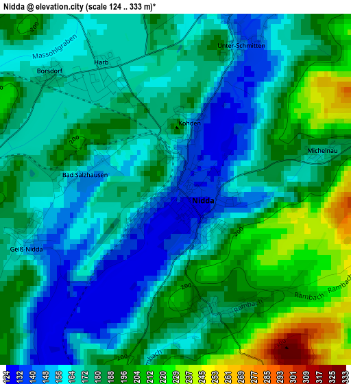
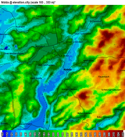
Below is the Elevation map of Nidda, which displays elevation range with different colors. Scale of the first map is from 124 to 333 m (407 to 1093 ft) with average elevation of 179.2 meters (=588 ft) [note 1]
These maps also provides idea of topography and contour of this city, they are displayed at different zoom levels. More info about maps, scale and edge coordinates you can find below images.
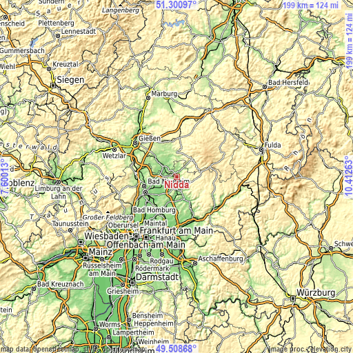
| \ | Map #1 | Map #2 | Topo.Map |
| Scale [m] | 124..333 m | 103..333 m | × |
| Scale [ft] | 407..1093 ft | 338..1093 ft | × |
| Average | 179.2 m = 588 ft | 197.4 m = 648 ft | × |
| Width | 6.23 km = 3.9 mi | 12.46 km = 7.7 mi | 199.3 km = 123.8 mi |
| Height | 6.23 km = 3.9 mi | 12.46 km = 7.7 mi | 199.3 km = 123.8 mi |
| ↑Max Latitude | 50.441296° | 50.469275° | 51.30097° |
| Latitude at center | 50.4133° | 50.4133° | 50.4133° |
| ↓Min Latitude | 50.385288° | 50.357259° | 49.50868° |
| ← Min Longitude | 8.962435° | 8.918489° | 7.60013° |
| Longitude center | 9.00638° | 9.00638° | 9.00638° |
| →Max Longitude | 9.050325° | 9.094271° | 10.41263° |
Nearby cities:
Cities around Nidda sort by population:
• Schotten elevation 282 m
13.1 km,  39°
39°
• Wölfersheim 153 m
13.5 km,  263°
263°
• Ortenberg 150 m
7.3 km,  151°
151°
• Gedern 317 m
13.7 km,  84°
84°
• Reichelsheim 128 m
11.3 km,  235°
235°
• Echzell 131 m
8.9 km,  252°
252°
• Ranstadt 137 m
6.4 km,  194°
194°
• Hungen 162 m
10.5 km,  309°
309°
• Glauburg 131 m
10.8 km,  182°
182°
• Hirzenhain 294 m
9.1 km,  99°
99°
• Berstadt 145 m
10 km,  278°
278°
• Wohnbach 159 m
12.7 km, 277°
Multilingual:
 En español:
Nidda elevación 135 m.
 En France:
Nidda élévation 135 m.


Sources and notes:
- [note 1] Map square and city borders are not equal. Map elevation data is calculated only from area inside that square.
- [src 1] Elevation data from geonames database provided with same terms of usage.
- [src 2] The elevation map of Nidda is generated using elevation data from NASA's 3 arcsec (90m) resolution SRTM data.
- [src 3] Base (background) map © OpenStreetMap contributors tiles are generated by Geofabrik and OpenTopoMap.
Copyright & License:
This Nidda Elevation Map is licensed under CC BY-SA. You may reuse any part from this page, if you give a proper credit by linking to this URL:
 More info on terms of use page.