Schotten elevation
Schotten (Hesse, Regierungsbezirk Gießen), Germany elevation is 282 meters and Schotten elevation in feet is 925 ft above sea level [src 1]. Schotten is a populated place (feature code) with elevation that is 24 meters (79 ft) bigger than average city elevation in Germany.
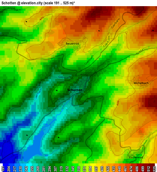
Below is the Elevation map of Schotten, which displays elevation range with different colors. Scale of the first map is from 191 to 525 m (627 to 1722 ft) with average elevation of 359.8 meters (=1180 ft) [note 1]
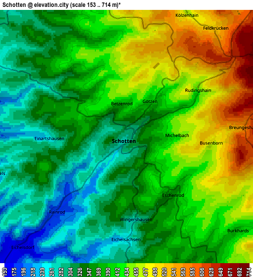
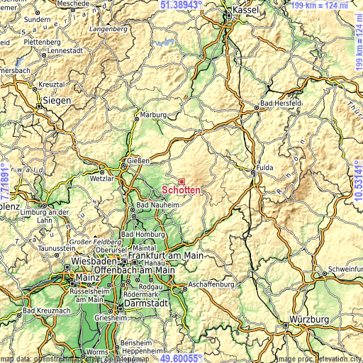
These maps also provides idea of topography and contour of this city, they are displayed at different zoom levels. More info about maps, scale and edge coordinates you can find below images.
| \ | Map #1 | Map #2 | Topo.Map |
| Scale [m] | 191..525 m | 153..714 m | × |
| Scale [ft] | 627..1722 ft | 502..2343 ft | × |
| Average | 359.8 m = 1180 ft | 384.6 m = 1262 ft | × |
| Width | 6.22 km = 3.9 mi | 12.43 km = 7.7 mi | 198.9 km = 123.6 mi |
| Height | 6.22 km = 3.9 mi | 12.43 km = 7.7 mi | 198.9 km = 123.6 mi |
| ↑Max Latitude | 50.531402° | 50.559328° | 51.38943° |
| Latitude at center | 50.50346° | 50.50346° | 50.50346° |
| ↓Min Latitude | 50.475501° | 50.447526° | 49.60055° |
| ← Min Longitude | 9.081215° | 9.037269° | 7.71891° |
| Longitude center | 9.12516° | 9.12516° | 9.12516° |
| →Max Longitude | 9.169105° | 9.213051° | 10.53141° |
Nearby cities:
Cities around Schotten sort by population:
• Nidda elevation 135 m
13.1 km,  219°
219°
• Grünberg 269 m
15.5 km,  310°
310°
• Laubach 209 m
10.4 km,  294°
294°
• Ortenberg 150 m
17.1 km,  196°
196°
• Gedern 317 m
10.2 km,  149°
149°
• Grebenhain 435 m
15.2 km,  95°
95°
• Herbstein 435 m
16.9 km,  67°
67°
• Hungen 162 m
16.7 km,  258°
258°
• Ulrichstein 578 m
9.3 km,  30°
30°
• Kefenrod 261 m
18.7 km,  160°
160°
• Hirzenhain 294 m
11.5 km,  177°
177°
• Lautertal 519 m
14.3 km,  51°
51°
Multilingual:
 En español:
Schotten elevación 282 m.
 En France:
Schotten élévation 282 m.
 Auf Deutsch:
Schotten höhe über dem Meeresspiegel ist 282 m.

Sources and notes:
- [note 1] Map square and city borders are not equal. Map elevation data is calculated only from area inside that square.
- [src 1] Elevation data from geonames database provided with same terms of usage.
- [src 2] The elevation map of Schotten is generated using elevation data from NASA's 3 arcsec (90m) resolution SRTM data.
- [src 3] Base (background) map © OpenStreetMap contributors tiles are generated by Geofabrik and OpenTopoMap.
Copyright & License:
This Schotten Elevation Map is licensed under CC BY-SA. You may reuse any part from this page, if you give a proper credit by linking to this URL:
 More info on terms of use page.