Oberhof elevation
Oberhof (Thuringia), Germany elevation is 819 meters and Oberhof elevation in feet is 2687 ft above sea level [src 1]. Oberhof is a populated place (feature code) with elevation that is 561 meters (1841 ft) bigger than average city elevation in Germany.
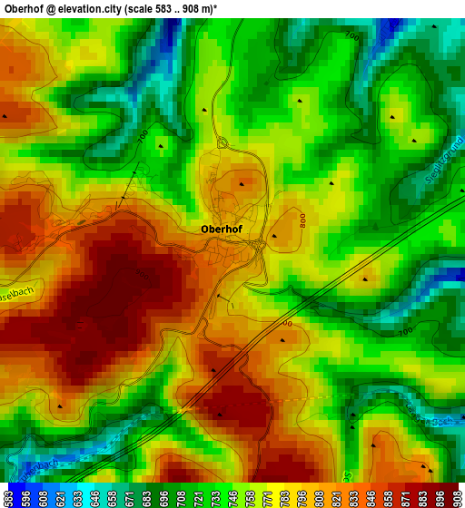
Below is the Elevation map of Oberhof, which displays elevation range with different colors. Scale of the first map is from 583 to 908 m (1913 to 2979 ft) with average elevation of 763.3 meters (=2504 ft) [note 1]
These maps also provides idea of topography and contour of this city, they are displayed at different zoom levels. More info about maps, scale and edge coordinates you can find below images.
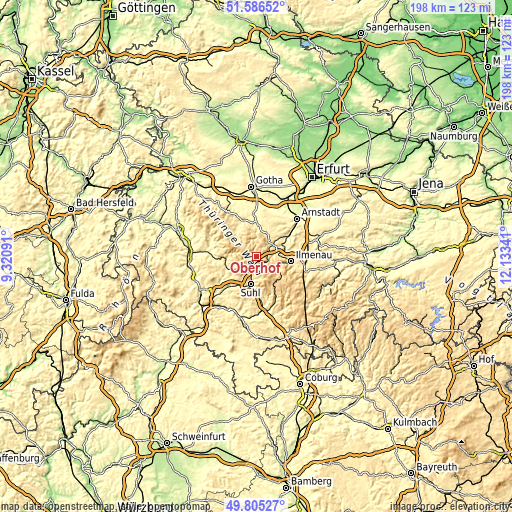
| \ | Map #1 | Topo.Map |
| Scale [m] | 583..908 m | × |
| Scale [ft] | 1913..2979 ft | × |
| Average | 763.3 m = 2504 ft | × |
| Width | 6.19 km = 3.8 mi | 198.1 km = 123.1 mi |
| Height | 6.19 km = 3.8 mi | 198 km = 123 mi |
| ↑Max Latitude | 50.732173° | 51.58652° |
| Latitude at center | 50.70435° | 50.70435° |
| ↓Min Latitude | 50.67651° | 49.80527° |
| ← Min Longitude | 10.683215° | 9.32091° |
| Longitude center | 10.72716° | 10.72716° |
| →Max Longitude | 10.771105° | 12.13341° |
Nearby cities:
Cities around Oberhof sort by population:
• Suhl elevation 442 m
10.8 km,  192°
192°
• Zella-Mehlis 485 m
7.1 km,  221°
221°
• Steinbach-Hallenberg 435 m
11.4 km,  265°
265°
• Gräfenroda 404 m
7.6 km,  50°
50°
• Benshausen 411 m
10.8 km,  236°
236°
• Geraberg 437 m
7.9 km,  80°
80°
• Geschwenda 471 m
7.6 km,  66°
66°
• Schmiedefeld am Rennsteig 697 m
12.2 km,  150°
150°
• Wölfis 419 m
12.1 km,  17°
17°
• Crawinkel 465 m
9.6 km, 24°
• Luisenthal 698 m
8.8 km,  2°
2°
• Elgersburg 492 m
8.9 km,  88°
88°
Multilingual:
 En español:
Oberhof elevación 819 m.
 En France:
Oberhof élévation 819 m.


Sources and notes:
- [note 1] Map square and city borders are not equal. Map elevation data is calculated only from area inside that square.
- [src 1] Elevation data from geonames database provided with same terms of usage.
- [src 2] The elevation map of Oberhof is generated using elevation data from NASA's 3 arcsec (90m) resolution SRTM data.
- [src 3] Base (background) map © OpenStreetMap contributors tiles are generated by Geofabrik and OpenTopoMap.
Copyright & License:
This Oberhof Elevation Map is licensed under CC BY-SA. You may reuse any part from this page, if you give a proper credit by linking to this URL:
 More info on terms of use page.