Suhl elevation
Suhl (Thuringia), Germany elevation is 442 meters and Suhl elevation in feet is 1450 ft above sea level [src 1]. Suhl is a seat of a third-order administrative division (feature code) with elevation that is 184 meters (604 ft) bigger than average city elevation in Germany.
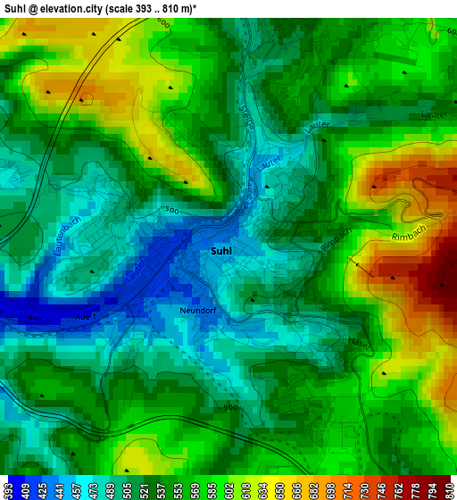
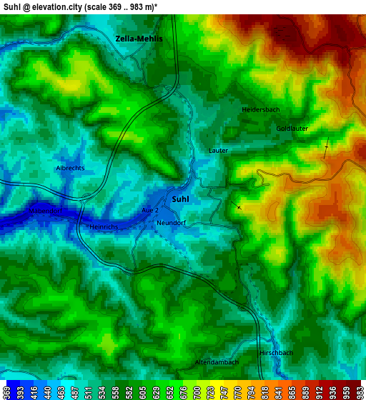
Below is the Elevation map of Suhl, which displays elevation range with different colors. Scale of the first map is from 393 to 810 m (1289 to 2657 ft) with average elevation of 547.8 meters (=1797 ft) [note 1]
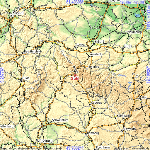
These maps also provides idea of topography and contour of this city, they are displayed at different zoom levels. More info about maps, scale and edge coordinates you can find below images.
| \ | Map #1 | Map #2 | Topo.Map |
| Scale [m] | 393..810 m | 369..983 m | × |
| Scale [ft] | 1289..2657 ft | 1211..3225 ft | × |
| Average | 547.8 m = 1797 ft | 598.5 m = 1964 ft | × |
| Width | 6.2 km = 3.9 mi | 12.4 km = 7.7 mi | 198.5 km = 123.3 mi |
| Height | 6.2 km = 3.9 mi | 12.4 km = 7.7 mi | 198.4 km = 123.3 mi |
| ↑Max Latitude | 50.63699° | 50.664853° | 51.49308° |
| Latitude at center | 50.60911° | 50.60911° | 50.60911° |
| ↓Min Latitude | 50.581214° | 50.553301° | 49.70821° |
| ← Min Longitude | 10.650065° | 10.606119° | 9.28776° |
| Longitude center | 10.69401° | 10.69401° | 10.69401° |
| →Max Longitude | 10.737955° | 10.781901° | 12.10026° |
Nearby cities:
Cities around Suhl sort by population:
• Zella-Mehlis elevation 485 m
5.8 km,  335°
335°
• Schleusingen 411 m
11.8 km,  157°
157°
• Steinbach-Hallenberg 435 m
13.3 km,  316°
316°
• Sankt Kilian 396 m
10.3 km,  151°
151°
• Themar 330 m
12.9 km,  205°
205°
• Benshausen 411 m
8 km,  304°
304°
• Viernau 393 m
11.3 km, 301°
• Schmiedefeld am Rennsteig 697 m
8.4 km,  90°
90°
• Stützerbach 660 m
12.5 km,  77°
77°
• Oberhof 819 m
10.8 km,  12°
12°
• Frauenwald 752 m
11.9 km,  103°
103°
• Rohr 341 m
14.4 km,  255°
255°
Multilingual:
 En español:
Suhl elevación 442 m.
 En France:
Suhl élévation 442 m.


Sources and notes:
- [note 1] Map square and city borders are not equal. Map elevation data is calculated only from area inside that square.
- [src 1] Elevation data from geonames database provided with same terms of usage.
- [src 2] The elevation map of Suhl is generated using elevation data from NASA's 3 arcsec (90m) resolution SRTM data.
- [src 3] Base (background) map © OpenStreetMap contributors tiles are generated by Geofabrik and OpenTopoMap.
Copyright & License:
This Suhl Elevation Map is licensed under CC BY-SA. You may reuse any part from this page, if you give a proper credit by linking to this URL:
 More info on terms of use page.