Pronstorf elevation
Pronstorf (Schleswig-Holstein), Germany elevation is 26 meters and Pronstorf elevation in feet is 85 ft above sea level [src 1]. Pronstorf is a seat of a fourth-order administrative division (feature code) with elevation that is 232 meters (761 ft) smaller than average city elevation in Germany.
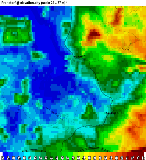
Below is the Elevation map of Pronstorf, which displays elevation range with different colors. Scale of the first map is from 22 to 77 m (72 to 253 ft) with average elevation of 37.7 meters (=124 ft) [note 1]
These maps also provides idea of topography and contour of this city, they are displayed at different zoom levels. More info about maps, scale and edge coordinates you can find below images.
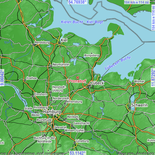
| \ | Map #1 | Topo.Map |
| Scale [m] | 22..77 m | × |
| Scale [ft] | 72..253 ft | × |
| Average | 37.7 m = 124 ft | × |
| Width | 5.75 km = 3.6 mi | 184 km = 114.3 mi |
| Height | 5.75 km = 3.6 mi | 184 km = 114.3 mi |
| ↑Max Latitude | 53.975853° | 54.76938° |
| Latitude at center | 53.95° | 53.95° |
| ↓Min Latitude | 53.924131° | 53.1142° |
| ← Min Longitude | 10.422725° | 9.06042° |
| Longitude center | 10.46667° | 10.46667° |
| →Max Longitude | 10.510615° | 11.87292° |
Nearby cities:
Cities around Pronstorf sort by population:
• Bad Oldesloe elevation 10 m
16.5 km,  201°
201°
• Bad Schwartau 11 m
15.5 km,  102°
102°
• Stockelsdorf 28 m
13.5 km,  118°
118°
• Bad Segeberg 40 m
10.8 km,  265°
265°
• Ahrensbök 62 m
9.6 km,  47°
47°
• Reinfeld 20 m
13.2 km,  173°
173°
• Seedorf 34 m
11.6 km,  343°
343°
• Fahrenkrug 60 m
14.2 km, 270°
• Zarpen 10 m
9.8 km,  160°
160°
• Klein Rönnau 24 m
10 km,  280°
280°
• Hamberge 15 m
15.1 km,  149°
149°
• Negernbötel 34 m
14.6 km, 284°
Multilingual:
 En español:
Pronstorf elevación 26 m.
 En France:
Pronstorf élévation 26 m.
 Auf Deutsch:
Pronstorf höhe über dem Meeresspiegel ist 26 m.

Sources and notes:
- [note 1] Map square and city borders are not equal. Map elevation data is calculated only from area inside that square.
- [src 1] Elevation data from geonames database provided with same terms of usage.
- [src 2] The elevation map of Pronstorf is generated using elevation data from NASA's 3 arcsec (90m) resolution SRTM data.
- [src 3] Base (background) map © OpenStreetMap contributors tiles are generated by Geofabrik and OpenTopoMap.
Copyright & License:
This Pronstorf Elevation Map is licensed under CC BY-SA. You may reuse any part from this page, if you give a proper credit by linking to this URL:
 More info on terms of use page.