Bad Schwartau elevation
Bad Schwartau (Schleswig-Holstein), Germany elevation is 11 meters and Bad Schwartau elevation in feet is 36 ft above sea level [src 1]. Bad Schwartau is a populated place (feature code) with elevation that is 247 meters (810 ft) smaller than average city elevation in Germany.
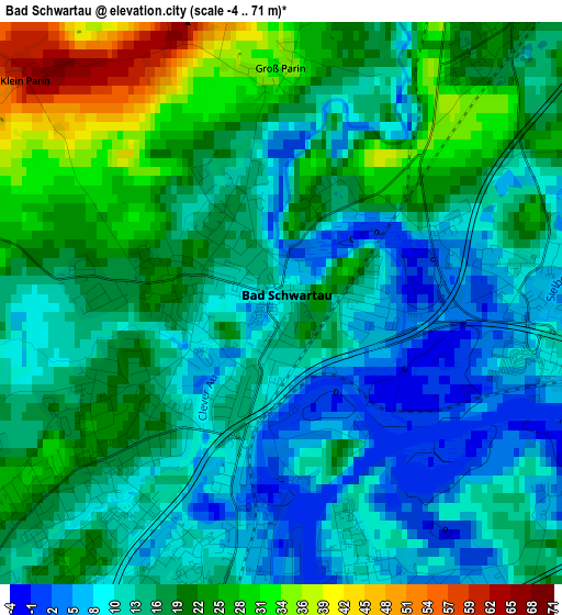
Below is the Elevation map of Bad Schwartau, which displays elevation range with different colors. Scale of the first map is from -4 to 71 m (-13 to 233 ft) with average elevation of 16.5 meters (=54 ft) [note 1]
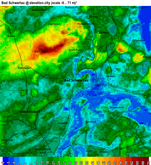
These maps also provides idea of topography and contour of this city, they are displayed at different zoom levels. More info about maps, scale and edge coordinates you can find below images.
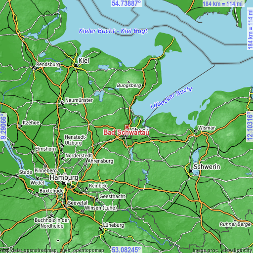
| \ | Map #1 | Map #2 | Topo.Map |
| Scale [m] | -4..71 m | -6..71 m | × |
| Scale [ft] | -13..233 ft | -20..233 ft | × |
| Average | 16.5 m = 54 ft | 17.8 m = 58 ft | × |
| Width | 5.76 km = 3.6 mi | 11.51 km = 7.2 mi | 184.2 km = 114.5 mi |
| Height | 5.76 km = 3.6 mi | 11.51 km = 7.2 mi | 184.2 km = 114.5 mi |
| ↑Max Latitude | 53.944743° | 53.970599° | 54.73887° |
| Latitude at center | 53.91887° | 53.91887° | 53.91887° |
| ↓Min Latitude | 53.892981° | 53.867076° | 53.08245° |
| ← Min Longitude | 10.652965° | 10.609019° | 9.29066° |
| Longitude center | 10.69691° | 10.69691° | 10.69691° |
| →Max Longitude | 10.740855° | 10.784801° | 12.10316° |
Nearby cities:
Cities around Bad Schwartau sort by population:
• Lübeck elevation 16 m
5.6 km,  186°
186°
• Stockelsdorf 28 m
4.4 km,  227°
227°
• Ratekau 17 m
4.2 km,  34°
34°
• Travemünde 5 m
12.4 km,  66°
66°
• Scharbeutz -2 m
13.2 km,  15°
15°
• Timmendorfer Strand 3 m
10 km, 31°
• Ahrensbök 62 m
12.8 km,  321°
321°
• Groß Grönau 8 m
13.7 km,  165°
165°
• Selmsdorf 35 m
11.4 km,  110°
110°
• Zarpen 10 m
13.2 km,  243°
243°
• Krummesse 10 m
15.4 km, 191°
• Hamberge 15 m
12.1 km,  218°
218°
Multilingual:
 En español:
Bad Schwartau elevación 11 m.
 En France:
Bad Schwartau élévation 11 m.
 Auf Deutsch:
Bad Schwartau höhe über dem Meeresspiegel ist 11 m.

Sources and notes:
- [note 1] Map square and city borders are not equal. Map elevation data is calculated only from area inside that square.
- [src 1] Elevation data from geonames database provided with same terms of usage.
- [src 2] The elevation map of Bad Schwartau is generated using elevation data from NASA's 3 arcsec (90m) resolution SRTM data.
- [src 3] Base (background) map © OpenStreetMap contributors tiles are generated by Geofabrik and OpenTopoMap.
Copyright & License:
This Bad Schwartau Elevation Map is licensed under CC BY-SA. You may reuse any part from this page, if you give a proper credit by linking to this URL:
 More info on terms of use page.