Rhede elevation
Rhede (North Rhine-Westphalia, Regierungsbezirk Münster), Germany elevation is 31 meters and Rhede elevation in feet is 102 ft above sea level [src 1]. Rhede is a populated place (feature code) with elevation that is 227 meters (745 ft) smaller than average city elevation in Germany.
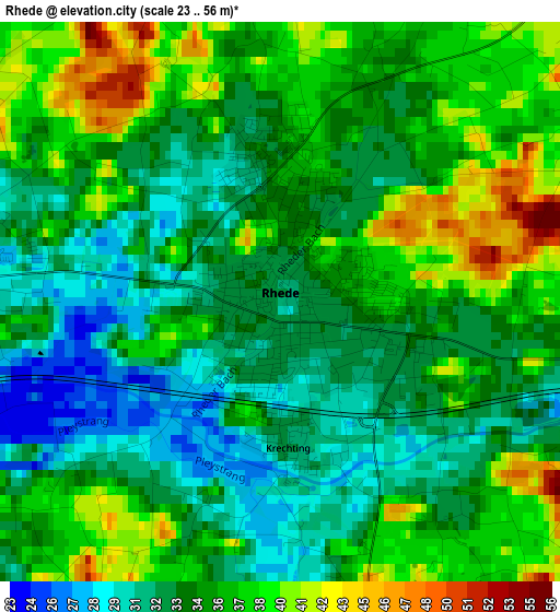
Below is the Elevation map of Rhede, which displays elevation range with different colors. Scale of the first map is from 23 to 56 m (75 to 184 ft) with average elevation of 34.9 meters (=115 ft) [note 1]
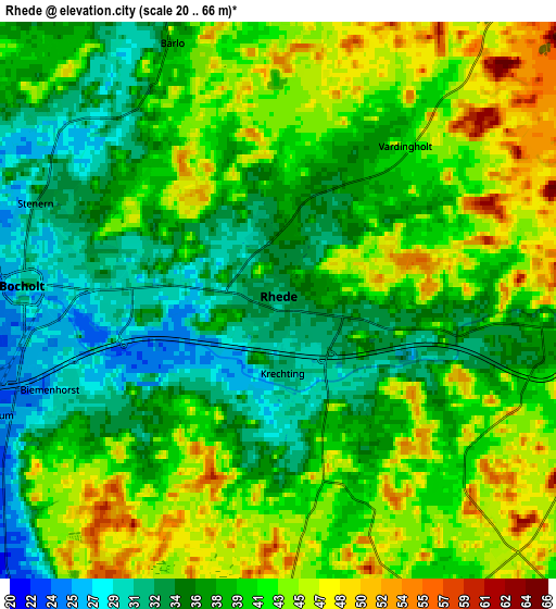
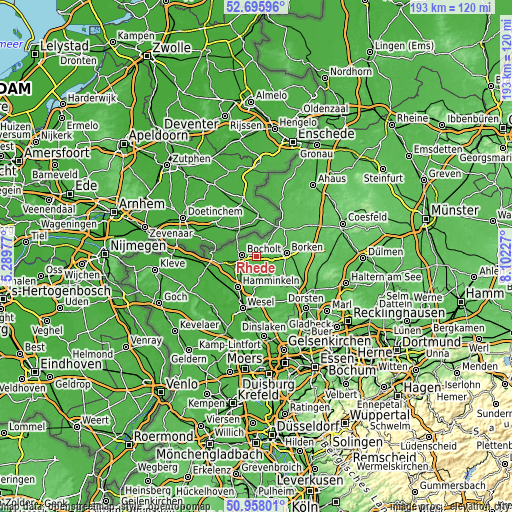
These maps also provides idea of topography and contour of this city, they are displayed at different zoom levels. More info about maps, scale and edge coordinates you can find below images.
| \ | Map #1 | Map #2 | Topo.Map |
| Scale [m] | 23..56 m | 20..66 m | × |
| Scale [ft] | 75..184 ft | 66..217 ft | × |
| Average | 34.9 m = 115 ft | 39.4 m = 129 ft | × |
| Width | 6.04 km = 3.8 mi | 12.08 km = 7.5 mi | 193.2 km = 120 mi |
| Height | 6.04 km = 3.8 mi | 12.08 km = 7.5 mi | 193.2 km = 120 mi |
| ↑Max Latitude | 51.862517° | 51.889647° | 52.69596° |
| Latitude at center | 51.83537° | 51.83537° | 51.83537° |
| ↓Min Latitude | 51.808207° | 51.781028° | 50.95801° |
| ← Min Longitude | 6.652075° | 6.608129° | 5.28977° |
| Longitude center | 6.69602° | 6.69602° | 6.69602° |
| →Max Longitude | 6.739965° | 6.783911° | 8.10227° |
Nearby cities:
Cities around Rhede sort by population:
• Bocholt elevation 31 m
5.6 km,  273°
273°
• Wesel 23 m
19.4 km,  195°
195°
• Borken 48 m
11.1 km,  85°
85°
• Hamminkeln 25 m
13.5 km,  212°
212°
• Rees 21 m
22 km,  248°
248°
• Schermbeck 32 m
20.6 km,  145°
145°
• Velen 60 m
21.1 km,  71°
71°
• Isselburg 20 m
15.9 km, 268°
• Raesfeld 62 m
13.1 km,  125°
125°
• Südlohn 51 m
16 km,  47°
47°
• Heiden 70 m
16.3 km, 90°
• Mehrhoog 23 m
16.7 km,  229°
229°
Multilingual:
 En español:
Rhede elevación 31 m.
 En France:
Rhede élévation 31 m.


Sources and notes:
- [note 1] Map square and city borders are not equal. Map elevation data is calculated only from area inside that square.
- [src 1] Elevation data from geonames database provided with same terms of usage.
- [src 2] The elevation map of Rhede is generated using elevation data from NASA's 3 arcsec (90m) resolution SRTM data.
- [src 3] Base (background) map © OpenStreetMap contributors tiles are generated by Geofabrik and OpenTopoMap.
Copyright & License:
This Rhede Elevation Map is licensed under CC BY-SA. You may reuse any part from this page, if you give a proper credit by linking to this URL:
 More info on terms of use page.