Riedlingen elevation
Riedlingen (Baden-Württemberg, Tübingen Region), Germany elevation is 540 meters and Riedlingen elevation in feet is 1772 ft above sea level [src 1]. Riedlingen is a populated place (feature code) with elevation that is 282 meters (925 ft) bigger than average city elevation in Germany.
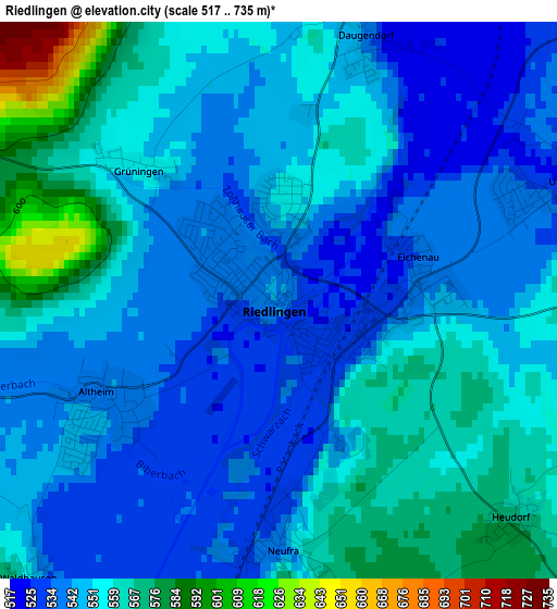
Below is the Elevation map of Riedlingen, which displays elevation range with different colors. Scale of the first map is from 517 to 735 m (1696 to 2411 ft) with average elevation of 551.1 meters (=1808 ft) [note 1]
These maps also provides idea of topography and contour of this city, they are displayed at different zoom levels. More info about maps, scale and edge coordinates you can find below images.
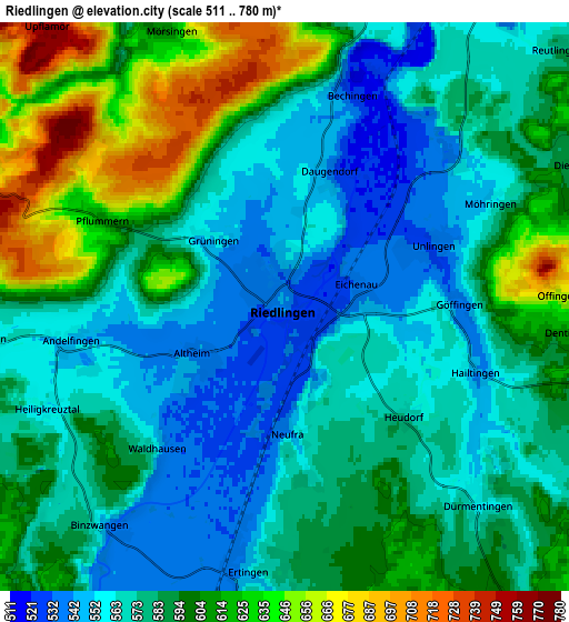
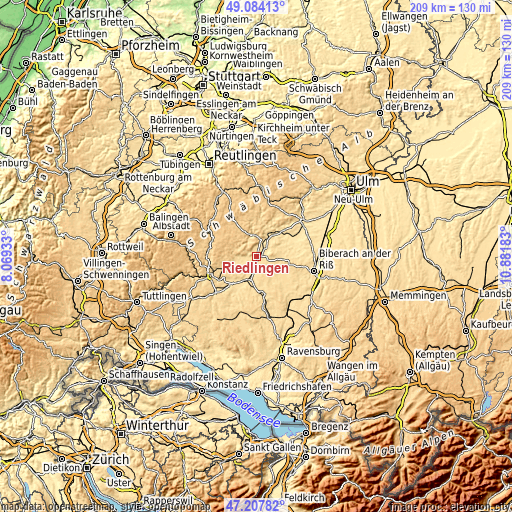
| \ | Map #1 | Map #2 | Topo.Map |
| Scale [m] | 517..735 m | 511..780 m | × |
| Scale [ft] | 1696..2411 ft | 1677..2559 ft | × |
| Average | 551.1 m = 1808 ft | 586.5 m = 1924 ft | × |
| Width | 6.52 km = 4.1 mi | 13.04 km = 8.1 mi | 208.6 km = 129.6 mi |
| Height | 6.52 km = 4.1 mi | 13.04 km = 8.1 mi | 208.6 km = 129.6 mi |
| ↑Max Latitude | 48.183859° | 48.21315° | 49.08413° |
| Latitude at center | 48.15455° | 48.15455° | 48.15455° |
| ↓Min Latitude | 48.125225° | 48.095883° | 47.20782° |
| ← Min Longitude | 9.431635° | 9.387689° | 8.06933° |
| Longitude center | 9.47558° | 9.47558° | 9.47558° |
| →Max Longitude | 9.519525° | 9.563471° | 10.88183° |
Nearby cities:
Cities around Riedlingen sort by population:
• Ertingen elevation 572 m
6.1 km,  186°
186°
• Munderkingen 518 m
15.4 km,  54°
54°
• Herbertingen 546 m
10.3 km,  197°
197°
• Bad Buchau 589 m
14.4 km,  135°
135°
• Uttenweiler 576 m
10.5 km,  92°
92°
• Langenenslingen 573 m
7.3 km,  264°
264°
• Dürmentingen 556 m
6 km,  134°
134°
• Unlingen 535 m
3.7 km,  67°
67°
• Hayingen 664 m
13.4 km,  0°
0°
• Zwiefalten 551 m
8.9 km,  353°
353°
• Neufra 542 m
2.9 km,  180°
180°
• Obermarchtal 535 m
11.3 km,  39°
39°
Multilingual:
 En español:
Riedlingen elevación 540 m.
 En France:
Riedlingen élévation 540 m.
 Auf Deutsch:
Riedlingen höhe über dem Meeresspiegel ist 540 m.

Sources and notes:
- [note 1] Map square and city borders are not equal. Map elevation data is calculated only from area inside that square.
- [src 1] Elevation data from geonames database provided with same terms of usage.
- [src 2] The elevation map of Riedlingen is generated using elevation data from NASA's 3 arcsec (90m) resolution SRTM data.
- [src 3] Base (background) map © OpenStreetMap contributors tiles are generated by Geofabrik and OpenTopoMap.
Copyright & License:
This Riedlingen Elevation Map is licensed under CC BY-SA. You may reuse any part from this page, if you give a proper credit by linking to this URL:
 More info on terms of use page.