Rittersdorf elevation
Rittersdorf (Rheinland-Pfalz), Germany elevation is 291 meters and Rittersdorf elevation in feet is 955 ft above sea level [src 1]. Rittersdorf is a seat of a fourth-order administrative division (feature code) with elevation that is 33 meters (108 ft) bigger than average city elevation in Germany.
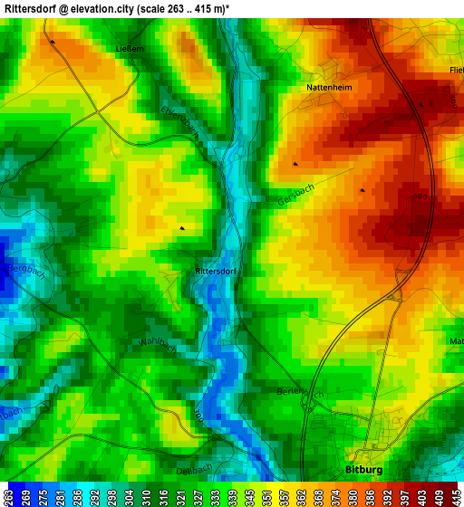
Below is the Elevation map of Rittersdorf, which displays elevation range with different colors. Scale of the first map is from 263 to 415 m (863 to 1362 ft) with average elevation of 339 meters (=1112 ft) [note 1]
These maps also provides idea of topography and contour of this city, they are displayed at different zoom levels. More info about maps, scale and edge coordinates you can find below images.
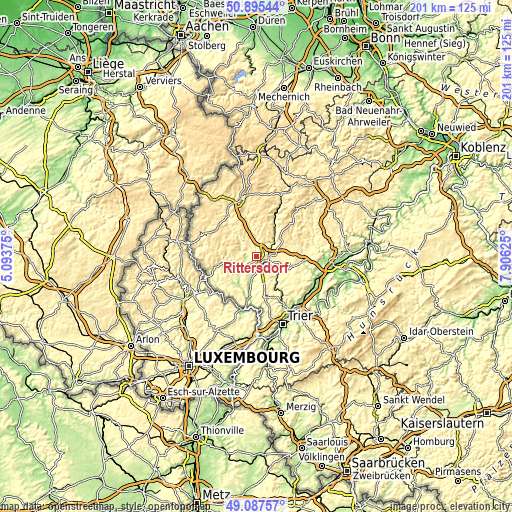
| \ | Map #1 | Topo.Map |
| Scale [m] | 263..415 m | × |
| Scale [ft] | 863..1362 ft | × |
| Average | 339 m = 1112 ft | × |
| Width | 6.28 km = 3.9 mi | 201 km = 124.9 mi |
| Height | 6.28 km = 3.9 mi | 201 km = 124.9 mi |
| ↑Max Latitude | 50.028239° | 50.89544° |
| Latitude at center | 50° | 50° |
| ↓Min Latitude | 49.971744° | 49.08757° |
| ← Min Longitude | 6.456055° | 5.09375° |
| Longitude center | 6.5° | 6.5° |
| →Max Longitude | 6.543945° | 7.90625° |
Nearby cities:
Cities around Rittersdorf sort by population:
• Bitburg elevation 327 m
4.1 km,  151°
151°
• Speicher 311 m
12.1 km,  127°
127°
• Welschbillig 357 m
17.3 km,  164°
164°
• Orenhofen 341 m
15.5 km,  136°
136°
• Badem 355 m
8.3 km,  90°
90°
• Waxweiler 341 m
14.2 km,  316°
316°
• Mettendorf 258 m
13.5 km,  244°
244°
• Binsfeld 323 m
15.9 km,  103°
103°
• Dudeldorf 277 m
10.2 km,  105°
105°
• Kyllburg 352 m
8 km,  57°
57°
• Bettingen 213 m
9.5 km,  227°
227°
• Herforst 314 m
15.3 km, 111°
Multilingual:
 En español:
Rittersdorf elevación 291 m.
 En France:
Rittersdorf élévation 291 m.
 Auf Deutsch:
Rittersdorf höhe über dem Meeresspiegel ist 291 m.

Sources and notes:
- [note 1] Map square and city borders are not equal. Map elevation data is calculated only from area inside that square.
- [src 1] Elevation data from geonames database provided with same terms of usage.
- [src 2] The elevation map of Rittersdorf is generated using elevation data from NASA's 3 arcsec (90m) resolution SRTM data.
- [src 3] Base (background) map © OpenStreetMap contributors tiles are generated by Geofabrik and OpenTopoMap.
Copyright & License:
This Rittersdorf Elevation Map is licensed under CC BY-SA. You may reuse any part from this page, if you give a proper credit by linking to this URL:
 More info on terms of use page.