Ronsberg elevation
Ronsberg (Bavaria, Swabia), Germany elevation is 696 meters and Ronsberg elevation in feet is 2283 ft above sea level [src 1]. Ronsberg is a populated place (feature code) with elevation that is 438 meters (1437 ft) bigger than average city elevation in Germany.
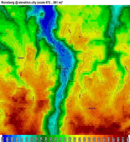
Below is the Elevation map of Ronsberg, which displays elevation range with different colors. Scale of the first map is from 672 to 881 m (2205 to 2890 ft) with average elevation of 788.5 meters (=2587 ft) [note 1]
These maps also provides idea of topography and contour of this city, they are displayed at different zoom levels. More info about maps, scale and edge coordinates you can find below images.
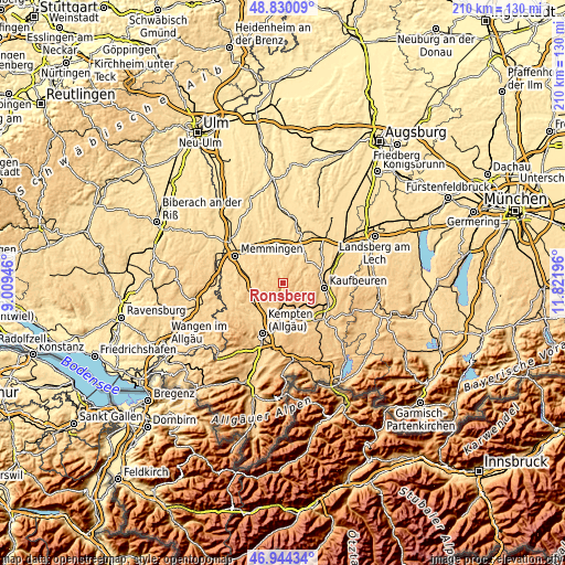
| \ | Map #1 | Topo.Map |
| Scale [m] | 672..881 m | × |
| Scale [ft] | 2205..2890 ft | × |
| Average | 788.5 m = 2587 ft | × |
| Width | 6.55 km = 4.1 mi | 209.7 km = 130.3 mi |
| Height | 6.55 km = 4.1 mi | 209.7 km = 130.3 mi |
| ↑Max Latitude | 47.925256° | 48.83009° |
| Latitude at center | 47.8958° | 47.8958° |
| ↓Min Latitude | 47.866327° | 46.94434° |
| ← Min Longitude | 10.371765° | 9.00946° |
| Longitude center | 10.41571° | 10.41571° |
| →Max Longitude | 10.459655° | 11.82196° |
Nearby cities:
Cities around Ronsberg sort by population:
• Ottobeuren elevation 655 m
10 km,  300°
300°
• Obergünzburg 737 m
5.6 km,  178°
178°
• Markt Rettenbach 676 m
5.9 km,  345°
345°
• Haldenwang 766 m
11.7 km,  204°
204°
• Wolfertschwenden 679 m
11.1 km,  268°
268°
• Friesenried 740 m
9.2 km,  104°
104°
• Günzach 774 m
8 km,  169°
169°
• Untrasried 855 m
7.4 km, 199°
• Unteregg 688 m
8.7 km,  25°
25°
• Baisweil 678 m
10.7 km,  59°
59°
• Irsee 746 m
11.7 km,  83°
83°
• Eggenthal 703 m
7.9 km,  72°
72°
Multilingual:
 En español:
Ronsberg elevación 696 m.
 En France:
Ronsberg élévation 696 m.
 Auf Deutsch:
Ronsberg höhe über dem Meeresspiegel ist 696 m.

Sources and notes:
- [note 1] Map square and city borders are not equal. Map elevation data is calculated only from area inside that square.
- [src 1] Elevation data from geonames database provided with same terms of usage.
- [src 2] The elevation map of Ronsberg is generated using elevation data from NASA's 3 arcsec (90m) resolution SRTM data.
- [src 3] Base (background) map © OpenStreetMap contributors tiles are generated by Geofabrik and OpenTopoMap.
Copyright & License:
This Ronsberg Elevation Map is licensed under CC BY-SA. You may reuse any part from this page, if you give a proper credit by linking to this URL:
 More info on terms of use page.