Sankt Goar elevation
Sankt Goar (Rheinland-Pfalz), Germany elevation is 208 meters and Sankt Goar elevation in feet is 682 ft above sea level [src 1]. Sankt Goar is a populated place (feature code) with elevation that is 50 meters (164 ft) smaller than average city elevation in Germany.
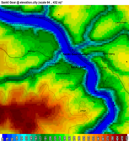
Below is the Elevation map of Sankt Goar, which displays elevation range with different colors. Scale of the first map is from 64 to 432 m (210 to 1417 ft) with average elevation of 232.7 meters (=763 ft) [note 1]
These maps also provides idea of topography and contour of this city, they are displayed at different zoom levels. More info about maps, scale and edge coordinates you can find below images.
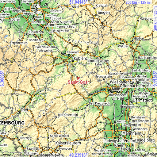
| \ | Map #1 | Topo.Map |
| Scale [m] | 64..432 m | × |
| Scale [ft] | 210..1417 ft | × |
| Average | 232.7 m = 763 ft | × |
| Width | 6.26 km = 3.9 mi | 200.4 km = 124.5 mi |
| Height | 6.26 km = 3.9 mi | 200.4 km = 124.5 mi |
| ↑Max Latitude | 50.176932° | 51.04143° |
| Latitude at center | 50.14878° | 50.14878° |
| ↓Min Latitude | 50.120612° | 49.23916° |
| ← Min Longitude | 7.663255° | 6.30095° |
| Longitude center | 7.7072° | 7.7072° |
| →Max Longitude | 7.751145° | 9.11345° |
Nearby cities:
Cities around Sankt Goar sort by population:
• Emmelshausen elevation 464 m
11.1 km,  273°
273°
• Nastätten 253 m
12.2 km,  62°
62°
• Oberwesel 90 m
4.7 km,  164°
164°
• Bacharach 86 m
11.1 km, 156°
• Miehlen 216 m
12.3 km,  46°
46°
• Kamp-Bornhofen 89 m
10.2 km,  324°
324°
• Sankt Goarshausen 162 m
1.2 km,  23°
23°
• Halsenbach 449 m
11 km,  283°
283°
• Weisel 397 m
7.5 km,  118°
118°
• Bornich 293 m
4.8 km, 120°
• Dachsenhausen 381 m
11.8 km,  6°
6°
• Kaub 77 m
7.7 km,  150°
150°
Multilingual:
 En español:
Sankt Goar elevación 208 m.
 En France:
Sankt Goar élévation 208 m.
 Auf Deutsch:
Sankt Goar höhe über dem Meeresspiegel ist 208 m.

Sources and notes:
- [note 1] Map square and city borders are not equal. Map elevation data is calculated only from area inside that square.
- [src 1] Elevation data from geonames database provided with same terms of usage.
- [src 2] The elevation map of Sankt Goar is generated using elevation data from NASA's 3 arcsec (90m) resolution SRTM data.
- [src 3] Base (background) map © OpenStreetMap contributors tiles are generated by Geofabrik and OpenTopoMap.
Copyright & License:
This Sankt Goar Elevation Map is licensed under CC BY-SA. You may reuse any part from this page, if you give a proper credit by linking to this URL:
 More info on terms of use page.