Sasbachwalden elevation
Sasbachwalden (Baden-Württemberg, Freiburg Region), Germany elevation is 316 meters and Sasbachwalden elevation in feet is 1037 ft above sea level [src 1]. Sasbachwalden is a seat of a fourth-order administrative division (feature code) with elevation that is 58 meters (190 ft) bigger than average city elevation in Germany.
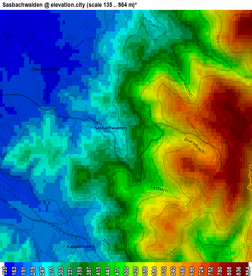
Below is the Elevation map of Sasbachwalden, which displays elevation range with different colors. Scale of the first map is from 135 to 864 m (443 to 2835 ft) with average elevation of 397.2 meters (=1303 ft) [note 1]
These maps also provides idea of topography and contour of this city, they are displayed at different zoom levels. More info about maps, scale and edge coordinates you can find below images.
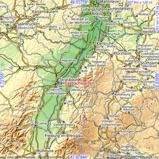
| \ | Map #1 | Topo.Map |
| Scale [m] | 135..864 m | × |
| Scale [ft] | 443..2835 ft | × |
| Average | 397.2 m = 1303 ft | × |
| Width | 6.46 km = 4 mi | 206.7 km = 128.4 mi |
| Height | 6.46 km = 4 mi | 206.7 km = 128.4 mi |
| ↑Max Latitude | 48.645714° | 49.53779° |
| Latitude at center | 48.61667° | 48.61667° |
| ↓Min Latitude | 48.58761° | 47.67844° |
| ← Min Longitude | 8.089385° | 6.72708° |
| Longitude center | 8.13333° | 8.13333° |
| →Max Longitude | 8.177275° | 9.53958° |
Nearby cities:
Cities around Sasbachwalden sort by population:
• Bühl elevation 138 m
8.9 km,  0°
0°
• Achern 145 m
4.5 km,  290°
290°
• Oberkirch 193 m
10.2 km,  203°
203°
• Bühlertal 245 m
8.7 km,  27°
27°
• Zell 130 m
9.9 km,  328°
328°
• Renchen 147 m
9.4 km,  250°
250°
• Haslach 178 m
8 km,  224°
224°
• Ottersweier 140 m
6.1 km,  346°
346°
• Kappelrodeck 215 m
3 km, 203°
• Sasbach 142 m
3.9 km,  311°
311°
• Lauf 220 m
3.7 km, 0°
• Seebach 400 m
5.3 km,  148°
148°
Multilingual:
 En español:
Sasbachwalden elevación 316 m.
 En France:
Sasbachwalden élévation 316 m.
 Auf Deutsch:
Sasbachwalden höhe über dem Meeresspiegel ist 316 m.

Sources and notes:
- [note 1] Map square and city borders are not equal. Map elevation data is calculated only from area inside that square.
- [src 1] Elevation data from geonames database provided with same terms of usage.
- [src 2] The elevation map of Sasbachwalden is generated using elevation data from NASA's 3 arcsec (90m) resolution SRTM data.
- [src 3] Base (background) map © OpenStreetMap contributors tiles are generated by Geofabrik and OpenTopoMap.
Copyright & License:
This Sasbachwalden Elevation Map is licensed under CC BY-SA. You may reuse any part from this page, if you give a proper credit by linking to this URL:
 More info on terms of use page.