Selb elevation
Selb (Bavaria, Upper Franconia), Germany elevation is 546 meters and Selb elevation in feet is 1791 ft above sea level [src 1]. Selb is a populated place (feature code) with elevation that is 288 meters (945 ft) bigger than average city elevation in Germany.
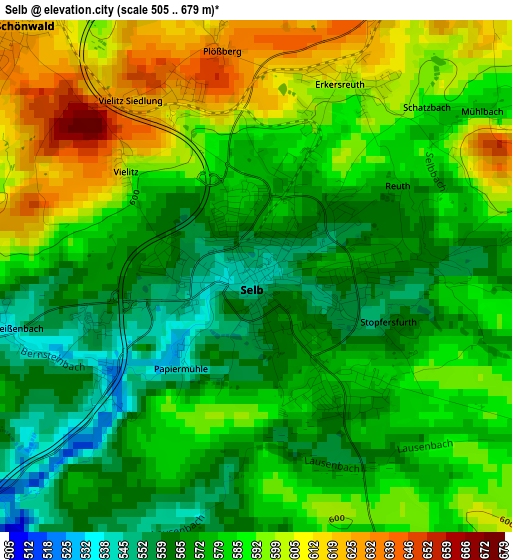
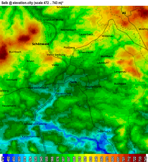
Below is the Elevation map of Selb, which displays elevation range with different colors. Scale of the first map is from 505 to 679 m (1657 to 2228 ft) with average elevation of 582.1 meters (=1910 ft) [note 1]
These maps also provides idea of topography and contour of this city, they are displayed at different zoom levels. More info about maps, scale and edge coordinates you can find below images.
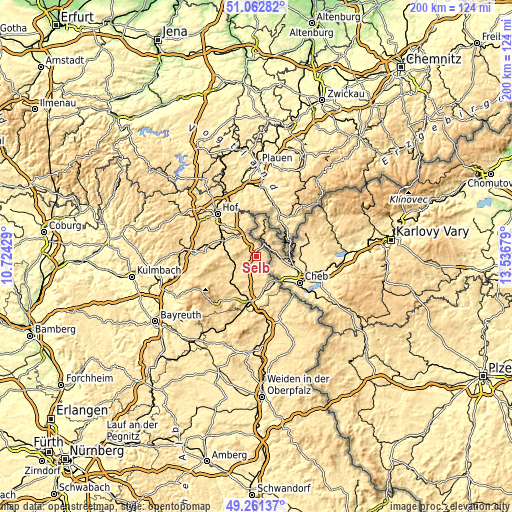
| \ | Map #1 | Map #2 | Topo.Map |
| Scale [m] | 505..679 m | 472..743 m | × |
| Scale [ft] | 1657..2228 ft | 1549..2438 ft | × |
| Average | 582.1 m = 1910 ft | 592.7 m = 1945 ft | × |
| Width | 6.26 km = 3.9 mi | 12.52 km = 7.8 mi | 200.3 km = 124.5 mi |
| Height | 6.26 km = 3.9 mi | 12.52 km = 7.8 mi | 200.3 km = 124.5 mi |
| ↑Max Latitude | 50.198719° | 50.226841° | 51.06282° |
| Latitude at center | 50.17058° | 50.17058° | 50.17058° |
| ↓Min Latitude | 50.142425° | 50.114253° | 49.26137° |
| ← Min Longitude | 12.086595° | 12.042649° | 10.72429° |
| Longitude center | 12.13054° | 12.13054° | 12.13054° |
| →Max Longitude | 12.174485° | 12.218431° | 13.53679° |
Nearby cities:
Cities around Selb sort by population:
• Rehau elevation 521 m
11.1 km,  321°
321°
• Arzberg 470 m
13.2 km,  162°
162°
• Kirchenlamitz 597 m
13.1 km,  260°
260°
• Schönwald 643 m
4.6 km,  314°
314°
• Marktleuthen 525 m
10.2 km,  243°
243°
• Röslau 563 m
14.3 km,  227°
227°
• Bad Brambach 579 m
14.2 km,  68°
68°
• Thiersheim 539 m
10.5 km,  181°
181°
• Hohenberg an der Eger 513 m
10.6 km,  142°
142°
• Schirnding 457 m
12 km, 144°
• Thierstein 601 m
7.4 km,  195°
195°
• Höchstädt bei Thiersheim 570 m
8.3 km, 201°
Multilingual:
 En español:
Selb elevación 546 m.
 En France:
Selb élévation 546 m.


Sources and notes:
- [note 1] Map square and city borders are not equal. Map elevation data is calculated only from area inside that square.
- [src 1] Elevation data from geonames database provided with same terms of usage.
- [src 2] The elevation map of Selb is generated using elevation data from NASA's 3 arcsec (90m) resolution SRTM data.
- [src 3] Base (background) map © OpenStreetMap contributors tiles are generated by Geofabrik and OpenTopoMap.
Copyright & License:
This Selb Elevation Map is licensed under CC BY-SA. You may reuse any part from this page, if you give a proper credit by linking to this URL:
 More info on terms of use page.