Sippersfeld elevation
Sippersfeld (Rheinland-Pfalz), Germany elevation is 314 meters and Sippersfeld elevation in feet is 1030 ft above sea level [src 1]. Sippersfeld is a seat of a fourth-order administrative division (feature code) with elevation that is 56 meters (184 ft) bigger than average city elevation in Germany.
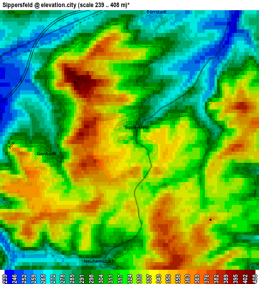
Below is the Elevation map of Sippersfeld, which displays elevation range with different colors. Scale of the first map is from 239 to 408 m (784 to 1339 ft) with average elevation of 315.5 meters (=1035 ft) [note 1]
These maps also provides idea of topography and contour of this city, they are displayed at different zoom levels. More info about maps, scale and edge coordinates you can find below images.
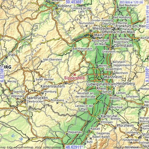
| \ | Map #1 | Topo.Map |
| Scale [m] | 239..408 m | × |
| Scale [ft] | 784..1339 ft | × |
| Average | 315.5 m = 1035 ft | × |
| Width | 6.34 km = 3.9 mi | 202.9 km = 126.1 mi |
| Height | 6.34 km = 3.9 mi | 202.9 km = 126.1 mi |
| ↑Max Latitude | 49.578503° | 50.45385° |
| Latitude at center | 49.55° | 49.55° |
| ↓Min Latitude | 49.521481° | 48.62911° |
| ← Min Longitude | 7.889385° | 6.52708° |
| Longitude center | 7.93333° | 7.93333° |
| →Max Longitude | 7.977275° | 9.33958° |
Nearby cities:
Cities around Sippersfeld sort by population:
• Enkenbach-Alsenborn elevation 298 m
7.8 km,  197°
197°
• Winnweiler 268 m
6.3 km,  287°
287°
• Mehlingen 309 m
8.6 km,  221°
221°
• Göllheim 247 m
9.8 km,  59°
59°
• Carlsberg 330 m
9.4 km,  123°
123°
• Kerzenheim 258 m
9.6 km,  72°
72°
• Ramsen 216 m
6 km,  104°
104°
• Wattenheim 328 m
9.8 km,  108°
108°
• Münchweiler an der Alsenz 254 m
3.6 km,  270°
270°
• Sembach 314 m
6.4 km,  228°
228°
• Imsbach 294 m
5.2 km,  315°
315°
• Dreisen 230 m
8.1 km,  43°
43°
Multilingual:
 En español:
Sippersfeld elevación 314 m.
 En France:
Sippersfeld élévation 314 m.
 Auf Deutsch:
Sippersfeld höhe über dem Meeresspiegel ist 314 m.

Sources and notes:
- [note 1] Map square and city borders are not equal. Map elevation data is calculated only from area inside that square.
- [src 1] Elevation data from geonames database provided with same terms of usage.
- [src 2] The elevation map of Sippersfeld is generated using elevation data from NASA's 3 arcsec (90m) resolution SRTM data.
- [src 3] Base (background) map © OpenStreetMap contributors tiles are generated by Geofabrik and OpenTopoMap.
Copyright & License:
This Sippersfeld Elevation Map is licensed under CC BY-SA. You may reuse any part from this page, if you give a proper credit by linking to this URL:
 More info on terms of use page.