Soest elevation
Soest (North Rhine-Westphalia, Regierungsbezirk Arnsberg), Germany elevation is 95 meters and Soest elevation in feet is 312 ft above sea level [src 1]. Soest is a seat of a third-order administrative division (feature code) with elevation that is 163 meters (535 ft) smaller than average city elevation in Germany.
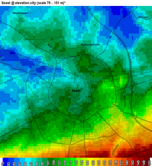
Below is the Elevation map of Soest, which displays elevation range with different colors. Scale of the first map is from 79 to 151 m (259 to 495 ft) with average elevation of 101.9 meters (=334 ft) [note 1]
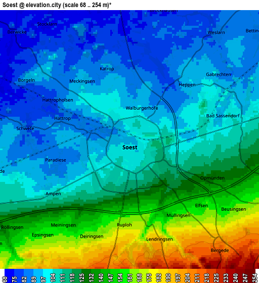
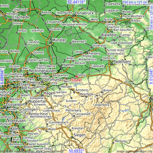
These maps also provides idea of topography and contour of this city, they are displayed at different zoom levels. More info about maps, scale and edge coordinates you can find below images.
| \ | Map #1 | Map #2 | Topo.Map |
| Scale [m] | 79..151 m | 68..254 m | × |
| Scale [ft] | 259..495 ft | 223..833 ft | × |
| Average | 101.9 m = 334 ft | 115.2 m = 378 ft | × |
| Width | 6.07 km = 3.8 mi | 12.15 km = 7.5 mi | 194.4 km = 120.8 mi |
| Height | 6.07 km = 3.8 mi | 12.15 km = 7.5 mi | 194.3 km = 120.7 mi |
| ↑Max Latitude | 51.602883° | 51.63017° | 52.44116° |
| Latitude at center | 51.57558° | 51.57558° | 51.57558° |
| ↓Min Latitude | 51.548261° | 51.520925° | 50.6932° |
| ← Min Longitude | 8.062245° | 8.018299° | 6.69994° |
| Longitude center | 8.10619° | 8.10619° | 8.10619° |
| →Max Longitude | 8.150135° | 8.194081° | 9.51244° |
Nearby cities:
Cities around Soest sort by population:
• Arnsberg elevation 295 m
21.4 km,  184°
184°
• Lippstadt 81 m
19.8 km,  56°
56°
• Beckum 116 m
20.5 km,  347°
347°
• Werl 92 m
13.5 km,  260°
260°
• Warstein 346 m
22.2 km,  130°
130°
• Erwitte 102 m
16.6 km,  75°
75°
• Wadersloh 95 m
20.2 km,  29°
29°
• Welver 76 m
10.7 km,  295°
295°
• Wickede 168 m
18.8 km,  242°
242°
• Bad Sassendorf 93 m
4.3 km, 78°
• Möhnesee 253 m
8.6 km,  167°
167°
• Anröchte 186 m
15.7 km,  93°
93°
Multilingual:
 En español:
Soest elevación 95 m.
 En France:
Soest élévation 95 m.


Sources and notes:
- [note 1] Map square and city borders are not equal. Map elevation data is calculated only from area inside that square.
- [src 1] Elevation data from geonames database provided with same terms of usage.
- [src 2] The elevation map of Soest is generated using elevation data from NASA's 3 arcsec (90m) resolution SRTM data.
- [src 3] Base (background) map © OpenStreetMap contributors tiles are generated by Geofabrik and OpenTopoMap.
Copyright & License:
This Soest Elevation Map is licensed under CC BY-SA. You may reuse any part from this page, if you give a proper credit by linking to this URL:
 More info on terms of use page.