Stendal elevation
Stendal (Saxony-Anhalt), Germany elevation is 34 meters and Stendal elevation in feet is 112 ft above sea level [src 1]. Stendal is a seat of a third-order administrative division (feature code) with elevation that is 224 meters (735 ft) smaller than average city elevation in Germany.
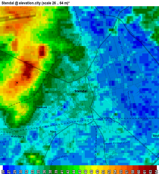
Below is the Elevation map of Stendal, which displays elevation range with different colors. Scale of the first map is from 26 to 64 m (85 to 210 ft) with average elevation of 35.6 meters (=117 ft) [note 1]
These maps also provides idea of topography and contour of this city, they are displayed at different zoom levels. More info about maps, scale and edge coordinates you can find below images.
| \ | Map #1 | Map #2 | Topo.Map |
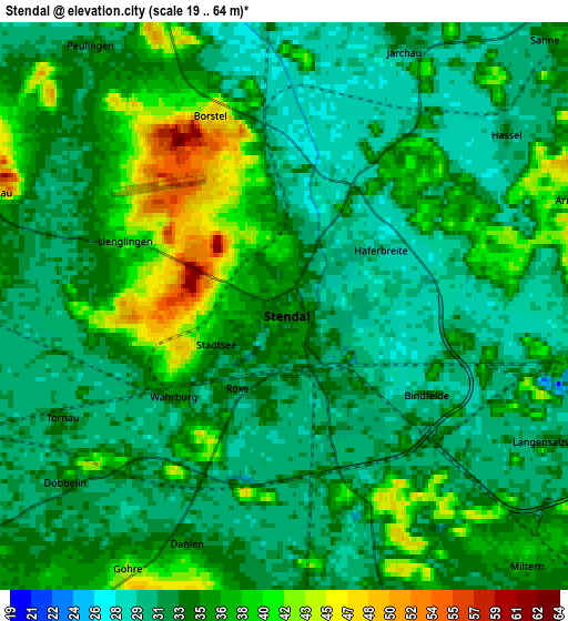
| Scale [m] | 26..64 m | 19..64 m | × |
| Scale [ft] | 85..210 ft | 62..210 ft | × |
| Average | 35.6 m = 117 ft | 34.2 m = 112 ft | × |
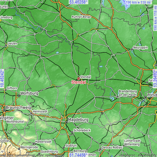
| Width | 5.93 km = 3.7 mi | 11.87 km = 7.4 mi | 189.9 km = 118 mi |
| Height | 5.93 km = 3.7 mi | 11.87 km = 7.4 mi | 189.9 km = 118 mi |
| ↑Max Latitude | 52.633579° | 52.660242° | 53.45258° |
| Latitude at center | 52.6069° | 52.6069° | 52.6069° |
| ↓Min Latitude | 52.580205° | 52.553493° | 51.74456° |
| ← Min Longitude | 11.814725° | 11.770779° | 10.45242° |
| Longitude center | 11.85867° | 11.85867° | 11.85867° |
| →Max Longitude | 11.902615° | 11.946561° | 13.26492° |
Nearby cities:
Cities around Stendal sort by population:
• Tangermünde elevation 43 m
10.5 km,  131°
131°
• Tangerhütte 39 m
19.4 km,  190°
190°
• Bismark 50 m
21.3 km,  286°
286°
• Jerichow 35 m
16.3 km,  136°
136°
• Schönhausen 32 m
12.5 km,  103°
103°
• Arneburg 56 m
12.5 km,  52°
52°
• Klietz 32 m
15.7 km,  64°
64°
• Uchtspringe 73 m
19 km,  247°
247°
• Goldbeck 28 m
12.2 km,  0°
0°
• Lüderitz 44 m
13.4 km,  215°
215°
• Uenglingen 40 m
3.6 km, 290°
• Flessau 29 m
21.2 km,  323°
323°
Multilingual:
 En español:
Stendal elevación 34 m.
 En France:
Stendal élévation 34 m.


Sources and notes:
- [note 1] Map square and city borders are not equal. Map elevation data is calculated only from area inside that square.
- [src 1] Elevation data from geonames database provided with same terms of usage.
- [src 2] The elevation map of Stendal is generated using elevation data from NASA's 3 arcsec (90m) resolution SRTM data.
- [src 3] Base (background) map © OpenStreetMap contributors tiles are generated by Geofabrik and OpenTopoMap.
Copyright & License:
This Stendal Elevation Map is licensed under CC BY-SA. You may reuse any part from this page, if you give a proper credit by linking to this URL:
 More info on terms of use page.