Tangerhütte elevation
Tangerhütte (Saxony-Anhalt), Germany elevation is 39 meters and Tangerhütte elevation in feet is 128 ft above sea level [src 1]. Tangerhütte is a populated place (feature code) with elevation that is 219 meters (719 ft) smaller than average city elevation in Germany.
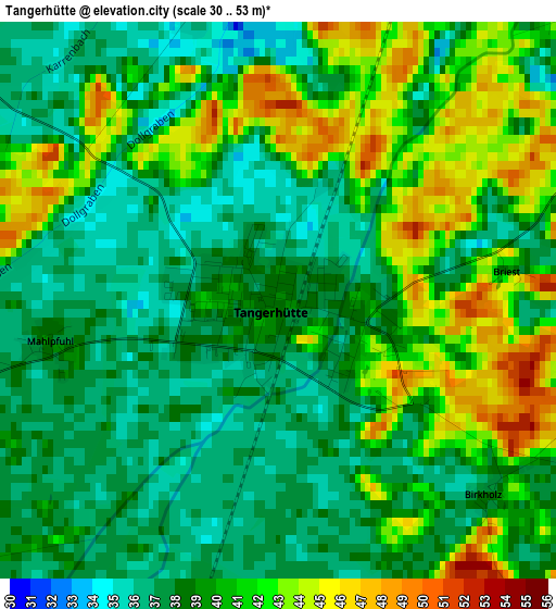
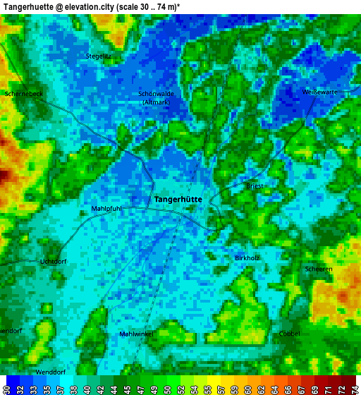
Below is the Elevation map of Tangerhütte, which displays elevation range with different colors. Scale of the first map is from 30 to 53 m (98 to 174 ft) with average elevation of 39.3 meters (=129 ft) [note 1]
These maps also provides idea of topography and contour of this city, they are displayed at different zoom levels. More info about maps, scale and edge coordinates you can find below images.
| \ | Map #1 | Map #2 | Topo.Map |
| Scale [m] | 30..53 m | 30..74 m | × |
| Scale [ft] | 98..174 ft | 98..243 ft | × |
| Average | 39.3 m = 129 ft | 41.9 m = 137 ft | × |
| Width | 5.96 km = 3.7 mi | 11.92 km = 7.4 mi | 190.7 km = 118.5 mi |
| Height | 5.96 km = 3.7 mi | 11.92 km = 7.4 mi | 190.6 km = 118.4 mi |
| ↑Max Latitude | 52.462083° | 52.488851° | 53.28431° |
| Latitude at center | 52.4353° | 52.4353° | 52.4353° |
| ↓Min Latitude | 52.4085° | 52.381684° | 51.56961° |
| ← Min Longitude | 11.763295° | 11.719349° | 10.40099° |
| Longitude center | 11.80724° | 11.80724° | 11.80724° |
| →Max Longitude | 11.851185° | 11.895131° | 13.21349° |
Nearby cities:
Cities around Tangerhütte sort by population:
• Stendal elevation 34 m
19.4 km,  10°
10°
• Burg bei Magdeburg 44 m
18.5 km,  169°
169°
• Tangermünde 43 m
16.7 km,  43°
43°
• Colbitz 58 m
19 km,  226°
226°
• Jerichow 35 m
16.4 km,  63°
63°
• Rogätz 46 m
13.5 km,  191°
191°
• Zielitz 53 m
18.5 km,  208°
208°
• Letzlingen 70 m
21.9 km,  273°
273°
• Uchtspringe 73 m
18.3 km,  309°
309°
• Angern 43 m
10.7 km, 207°
• Lüderitz 44 m
9.3 km,  332°
332°
• Uenglingen 40 m
20.3 km,  0°
0°
Multilingual:
 En español:
Tangerhütte elevación 39 m.
 En France:
Tangerhütte élévation 39 m.
 Auf Deutsch:
Tangerhütte höhe über dem Meeresspiegel ist 39 m.

Sources and notes:
- [note 1] Map square and city borders are not equal. Map elevation data is calculated only from area inside that square.
- [src 1] Elevation data from geonames database provided with same terms of usage.
- [src 2] The elevation map of Tangerhütte is generated using elevation data from NASA's 3 arcsec (90m) resolution SRTM data.
- [src 3] Base (background) map © OpenStreetMap contributors tiles are generated by Geofabrik and OpenTopoMap.
Copyright & License:
This Tangerhütte Elevation Map is licensed under CC BY-SA. You may reuse any part from this page, if you give a proper credit by linking to this URL:
 More info on terms of use page.