Templin elevation
Templin (Brandenburg), Germany elevation is 61 meters and Templin elevation in feet is 200 ft above sea level [src 1]. Templin is a populated place (feature code) with elevation that is 197 meters (646 ft) smaller than average city elevation in Germany.
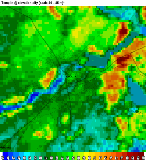
Below is the Elevation map of Templin, which displays elevation range with different colors. Scale of the first map is from 44 to 85 m (144 to 279 ft) with average elevation of 60.6 meters (=199 ft) [note 1]
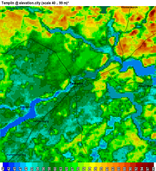
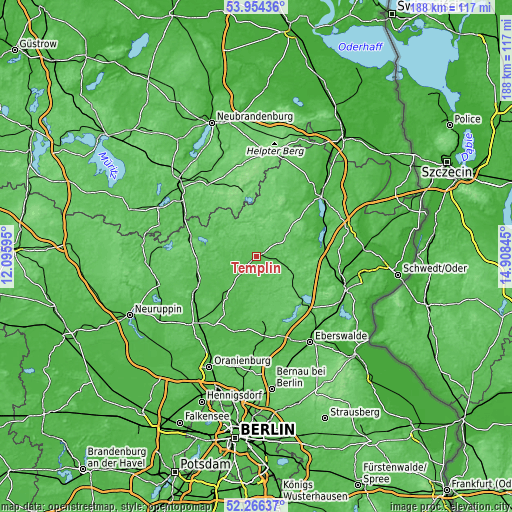
These maps also provides idea of topography and contour of this city, they are displayed at different zoom levels. More info about maps, scale and edge coordinates you can find below images.
| \ | Map #1 | Map #2 | Topo.Map |
| Scale [m] | 44..85 m | 40..99 m | × |
| Scale [ft] | 144..279 ft | 131..325 ft | × |
| Average | 60.6 m = 199 ft | 63.5 m = 208 ft | × |
| Width | 5.87 km = 3.6 mi | 11.73 km = 7.3 mi | 187.7 km = 116.6 mi |
| Height | 5.87 km = 3.6 mi | 11.73 km = 7.3 mi | 187.7 km = 116.6 mi |
| ↑Max Latitude | 53.145016° | 53.171366° | 53.95436° |
| Latitude at center | 53.11865° | 53.11865° | 53.11865° |
| ↓Min Latitude | 53.092268° | 53.065869° | 52.26637° |
| ← Min Longitude | 13.458255° | 13.414309° | 12.09595° |
| Longitude center | 13.5022° | 13.5022° | 13.5022° |
| →Max Longitude | 13.546145° | 13.590091° | 14.90845° |
Nearby cities:
Cities around Templin sort by population:
• Prenzlau elevation 32 m
32.5 km,  47°
47°
• Zehdenick 52 m
19.3 km,  216°
216°
• Fürstenberg 56 m
24.9 km,  287°
287°
• Gransee 55 m
26.2 km,  241°
241°
• Liebenwalde 43 m
28.4 km,  194°
194°
• Lychen 59 m
16.3 km,  309°
309°
• Joachimsthal 70 m
22.4 km,  133°
133°
• Gerswalde 51 m
17.4 km,  70°
70°
• Milmersdorf 61 m
9.3 km,  94°
94°
• Marienwerder 36 m
31.4 km,  168°
168°
• Carpin 74 m
31.6 km,  326°
326°
• Großwoltersdorf 61 m
27.5 km,  257°
257°
Multilingual:
 En español:
Templin elevación 61 m.
 En France:
Templin élévation 61 m.


Sources and notes:
- [note 1] Map square and city borders are not equal. Map elevation data is calculated only from area inside that square.
- [src 1] Elevation data from geonames database provided with same terms of usage.
- [src 2] The elevation map of Templin is generated using elevation data from NASA's 3 arcsec (90m) resolution SRTM data.
- [src 3] Base (background) map © OpenStreetMap contributors tiles are generated by Geofabrik and OpenTopoMap.
Copyright & License:
This Templin Elevation Map is licensed under CC BY-SA. You may reuse any part from this page, if you give a proper credit by linking to this URL:
 More info on terms of use page.