Zehdenick elevation
Zehdenick (Brandenburg), Germany elevation is 52 meters and Zehdenick elevation in feet is 171 ft above sea level [src 1]. Zehdenick is a populated place (feature code) with elevation that is 206 meters (676 ft) smaller than average city elevation in Germany.
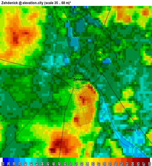
Below is the Elevation map of Zehdenick, which displays elevation range with different colors. Scale of the first map is from 35 to 68 m (115 to 223 ft) with average elevation of 48.5 meters (=159 ft) [note 1]
These maps also provides idea of topography and contour of this city, they are displayed at different zoom levels. More info about maps, scale and edge coordinates you can find below images.
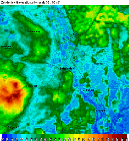
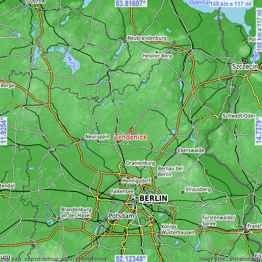
| \ | Map #1 | Map #2 | Topo.Map |
| Scale [m] | 35..68 m | 35..90 m | × |
| Scale [ft] | 115..223 ft | 115..295 ft | × |
| Average | 48.5 m = 159 ft | 50.9 m = 167 ft | × |
| Width | 5.88 km = 3.7 mi | 11.77 km = 7.3 mi | 188.3 km = 117 mi |
| Height | 5.88 km = 3.7 mi | 11.77 km = 7.3 mi | 188.3 km = 117 mi |
| ↑Max Latitude | 53.004972° | 53.031408° | 53.81697° |
| Latitude at center | 52.97852° | 52.97852° | 52.97852° |
| ↓Min Latitude | 52.952052° | 52.925567° | 52.12348° |
| ← Min Longitude | 13.287705° | 13.243759° | 11.9254° |
| Longitude center | 13.33165° | 13.33165° | 13.33165° |
| →Max Longitude | 13.375595° | 13.419541° | 14.7379° |
Nearby cities:
Cities around Zehdenick sort by population:
• Oranienburg elevation 35 m
25.5 km,  193°
193°
• Wandlitz 66 m
27.6 km,  162°
162°
• Templin 61 m
19.3 km,  36°
36°
• Fürstenberg 56 m
26.1 km,  331°
331°
• Gransee 55 m
12.1 km,  285°
285°
• Liebenwalde 43 m
12.7 km, 160°
• Lychen 59 m
26 km,  357°
357°
• Joachimsthal 70 m
27.7 km,  89°
89°
• Lindow 41 m
23.2 km,  266°
266°
• Milmersdorf 61 m
25.5 km,  54°
54°
• Marienwerder 36 m
23.5 km,  130°
130°
• Großwoltersdorf 61 m
18.3 km,  302°
302°
Multilingual:
 En español:
Zehdenick elevación 52 m.
 En France:
Zehdenick élévation 52 m.
 Auf Deutsch:
Zehdenick höhe über dem Meeresspiegel ist 52 m.

Sources and notes:
- [note 1] Map square and city borders are not equal. Map elevation data is calculated only from area inside that square.
- [src 1] Elevation data from geonames database provided with same terms of usage.
- [src 2] The elevation map of Zehdenick is generated using elevation data from NASA's 3 arcsec (90m) resolution SRTM data.
- [src 3] Base (background) map © OpenStreetMap contributors tiles are generated by Geofabrik and OpenTopoMap.
Copyright & License:
This Zehdenick Elevation Map is licensed under CC BY-SA. You may reuse any part from this page, if you give a proper credit by linking to this URL:
 More info on terms of use page.