Thurnau elevation
Thurnau (Bavaria, Upper Franconia), Germany elevation is 361 meters and Thurnau elevation in feet is 1184 ft above sea level [src 1]. Thurnau is a populated place (feature code) with elevation that is 103 meters (338 ft) bigger than average city elevation in Germany.
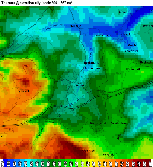
Below is the Elevation map of Thurnau, which displays elevation range with different colors. Scale of the first map is from 306 to 567 m (1004 to 1860 ft) with average elevation of 407.1 meters (=1336 ft) [note 1]
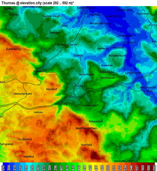
These maps also provides idea of topography and contour of this city, they are displayed at different zoom levels. More info about maps, scale and edge coordinates you can find below images.
| \ | Map #1 | Map #2 | Topo.Map |
| Scale [m] | 306..567 m | 292..592 m | × |
| Scale [ft] | 1004..1860 ft | 958..1942 ft | × |
| Average | 407.1 m = 1336 ft | 413.7 m = 1357 ft | × |
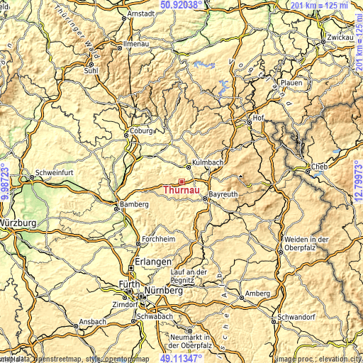
| Width | 6.28 km = 3.9 mi | 12.56 km = 7.8 mi | 200.9 km = 124.8 mi |
| Height | 6.28 km = 3.9 mi | 12.56 km = 7.8 mi | 200.9 km = 124.8 mi |
| ↑Max Latitude | 50.053644° | 50.081852° | 50.92038° |
| Latitude at center | 50.02542° | 50.02542° | 50.02542° |
| ↓Min Latitude | 49.997179° | 49.968922° | 49.11347° |
| ← Min Longitude | 11.349535° | 11.305589° | 9.98723° |
| Longitude center | 11.39348° | 11.39348° | 11.39348° |
| →Max Longitude | 11.437425° | 11.481371° | 12.79973° |
Nearby cities:
Cities around Thurnau sort by population:
• Kulmbach elevation 330 m
9.3 km,  25°
25°
• Mainleus 300 m
8.4 km,  351°
351°
• Hollfeld 405 m
12.2 km,  216°
216°
• Eckersdorf 352 m
0.4 km, 26°
• Weismain 318 m
12.8 km,  301°
301°
• Neudrossenfeld 344 m
7.7 km,  97°
97°
• Mistelgau 438 m
13.6 km,  157°
157°
• Kasendorf 381 m
3.2 km,  292°
292°
• Trebgast 332 m
12.1 km,  67°
67°
• Ködnitz 447 m
13 km,  50°
50°
• Wonsees 416 m
8.6 km,  230°
230°
• Harsdorf 398 m
12.4 km,  85°
85°
Multilingual:
 En español:
Thurnau elevación 361 m.
 En France:
Thurnau élévation 361 m.


Sources and notes:
- [note 1] Map square and city borders are not equal. Map elevation data is calculated only from area inside that square.
- [src 1] Elevation data from geonames database provided with same terms of usage.
- [src 2] The elevation map of Thurnau is generated using elevation data from NASA's 3 arcsec (90m) resolution SRTM data.
- [src 3] Base (background) map © OpenStreetMap contributors tiles are generated by Geofabrik and OpenTopoMap.
Copyright & License:
This Thurnau Elevation Map is licensed under CC BY-SA. You may reuse any part from this page, if you give a proper credit by linking to this URL:
 More info on terms of use page.