Unna elevation
Unna (North Rhine-Westphalia, Regierungsbezirk Arnsberg), Germany elevation is 103 meters and Unna elevation in feet is 338 ft above sea level [src 1]. Unna is a seat of a third-order administrative division (feature code) with elevation that is 155 meters (509 ft) smaller than average city elevation in Germany.
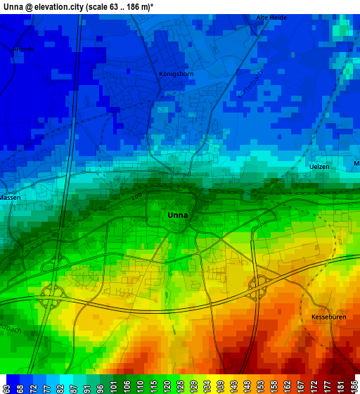
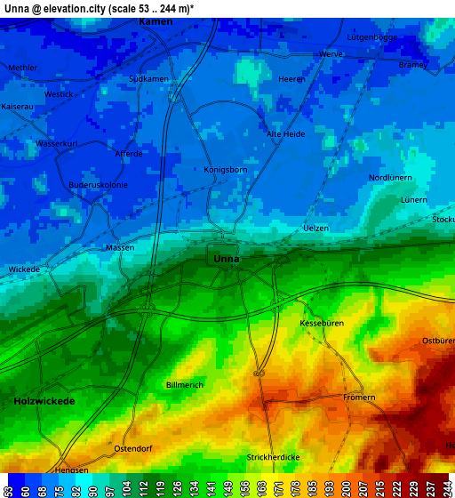
Below is the Elevation map of Unna, which displays elevation range with different colors. Scale of the first map is from 63 to 186 m (207 to 610 ft) with average elevation of 103.8 meters (=341 ft) [note 1]
These maps also provides idea of topography and contour of this city, they are displayed at different zoom levels. More info about maps, scale and edge coordinates you can find below images.

| \ | Map #1 | Map #2 | Topo.Map |
| Scale [m] | 63..186 m | 53..244 m | × |
| Scale [ft] | 207..610 ft | 174..801 ft | × |
| Average | 103.8 m = 341 ft | 111.9 m = 367 ft | × |
| Width | 6.08 km = 3.8 mi | 12.16 km = 7.6 mi | 194.5 km = 120.9 mi |
| Height | 6.08 km = 3.8 mi | 12.16 km = 7.6 mi | 194.5 km = 120.9 mi |
| ↑Max Latitude | 51.565276° | 51.592585° | 52.40425° |
| Latitude at center | 51.53795° | 51.53795° | 51.53795° |
| ↓Min Latitude | 51.510608° | 51.48325° | 50.65484° |
| ← Min Longitude | 7.645745° | 7.601799° | 6.28344° |
| Longitude center | 7.68969° | 7.68969° | 7.68969° |
| →Max Longitude | 7.733635° | 7.777581° | 9.09594° |
Nearby cities:
Cities around Unna sort by population:
• Lünen elevation 57 m
14.1 km,  308°
308°
• Menden 165 m
12.2 km,  149°
149°
• Bergkamen 67 m
9.3 km,  340°
340°
• Schwerte 124 m
13.5 km,  218°
218°
• Kamen 65 m
6.3 km, 343°
• Werl 92 m
15.6 km,  83°
83°
• Werne 60 m
14.6 km, 344°
• Fröndenberg 163 m
8.9 km,  141°
141°
• Bönen 73 m
8.7 km,  37°
37°
• Holzwickede 135 m
5.7 km, 222°
• Wickede 168 m
13 km,  110°
110°
• Lanstrop 75 m
9.4 km,  296°
296°
Multilingual:
 En español:
Unna elevación 103 m.
 En France:
Unna élévation 103 m.


Sources and notes:
- [note 1] Map square and city borders are not equal. Map elevation data is calculated only from area inside that square.
- [src 1] Elevation data from geonames database provided with same terms of usage.
- [src 2] The elevation map of Unna is generated using elevation data from NASA's 3 arcsec (90m) resolution SRTM data.
- [src 3] Base (background) map © OpenStreetMap contributors tiles are generated by Geofabrik and OpenTopoMap.
Copyright & License:
This Unna Elevation Map is licensed under CC BY-SA. You may reuse any part from this page, if you give a proper credit by linking to this URL:
 More info on terms of use page.