Unterschneidheim elevation
Unterschneidheim (Baden-Württemberg, Regierungsbezirk Stuttgart), Germany elevation is 475 meters and Unterschneidheim elevation in feet is 1558 ft above sea level [src 1]. Unterschneidheim is a seat of a fourth-order administrative division (feature code) with elevation that is 217 meters (712 ft) bigger than average city elevation in Germany.
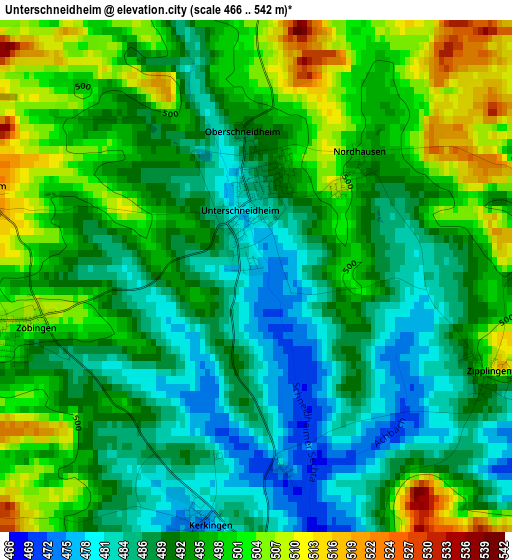
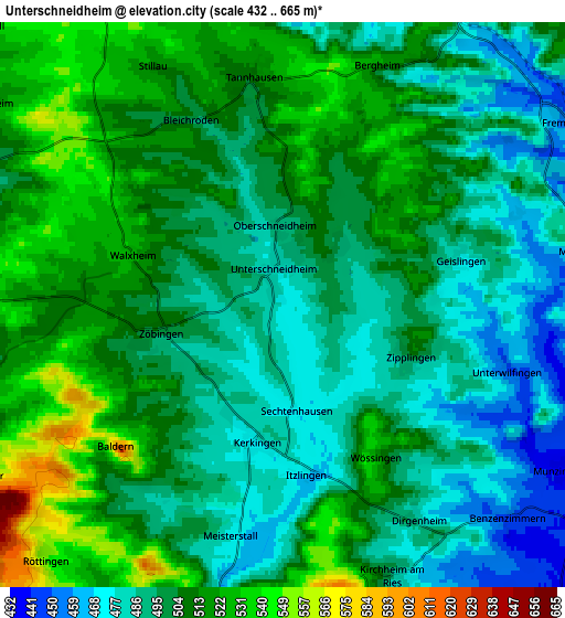
Below is the Elevation map of Unterschneidheim, which displays elevation range with different colors. Scale of the first map is from 466 to 542 m (1529 to 1778 ft) with average elevation of 493.5 meters (=1619 ft) [note 1]
These maps also provides idea of topography and contour of this city, they are displayed at different zoom levels. More info about maps, scale and edge coordinates you can find below images.
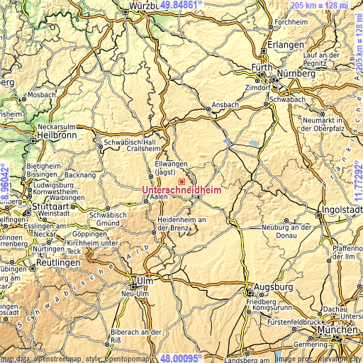
| \ | Map #1 | Map #2 | Topo.Map |
| Scale [m] | 466..542 m | 432..665 m | × |
| Scale [ft] | 1529..1778 ft | 1417..2182 ft | × |
| Average | 493.5 m = 1619 ft | 501.7 m = 1646 ft | × |
| Width | 6.42 km = 4 mi | 12.84 km = 8 mi | 205.4 km = 127.6 mi |
| Height | 6.42 km = 4 mi | 12.84 km = 8 mi | 205.4 km = 127.6 mi |
| ↑Max Latitude | 48.962191° | 48.991035° | 49.84861° |
| Latitude at center | 48.93333° | 48.93333° | 48.93333° |
| ↓Min Latitude | 48.904452° | 48.875558° | 48.00095° |
| ← Min Longitude | 10.322725° | 10.278779° | 8.96042° |
| Longitude center | 10.36667° | 10.36667° | 10.36667° |
| →Max Longitude | 10.410615° | 10.454561° | 11.77292° |
Nearby cities:
Cities around Unterschneidheim sort by population:
• Nördlingen elevation 437 m
12.8 km,  135°
135°
• Bopfingen 463 m
8.4 km,  186°
186°
• Lauchheim 491 m
11.4 km,  232°
232°
• Wallerstein 450 m
9.5 km,  122°
122°
• Fremdingen 446 m
7.9 km,  56°
56°
• Wilburgstetten 444 m
10.3 km,  11°
11°
• Kirchheim am Ries 498 m
6.5 km,  157°
157°
• Stödtlen 466 m
8.9 km,  326°
326°
• Tannhausen 517 m
5.1 km,  355°
355°
• Mönchsroth 444 m
9.5 km, 356°
• Marktoffingen 448 m
7.7 km,  96°
96°
• Maihingen 429 m
9.7 km,  93°
93°
Multilingual:
 En español:
Unterschneidheim elevación 475 m.
 En France:
Unterschneidheim élévation 475 m.
 Auf Deutsch:
Unterschneidheim höhe über dem Meeresspiegel ist 475 m.

Sources and notes:
- [note 1] Map square and city borders are not equal. Map elevation data is calculated only from area inside that square.
- [src 1] Elevation data from geonames database provided with same terms of usage.
- [src 2] The elevation map of Unterschneidheim is generated using elevation data from NASA's 3 arcsec (90m) resolution SRTM data.
- [src 3] Base (background) map © OpenStreetMap contributors tiles are generated by Geofabrik and OpenTopoMap.
Copyright & License:
This Unterschneidheim Elevation Map is licensed under CC BY-SA. You may reuse any part from this page, if you give a proper credit by linking to this URL:
 More info on terms of use page.