Villingen-Schwenningen elevation
Villingen-Schwenningen (Baden-Württemberg, Freiburg Region), Germany elevation is 757 meters and Villingen-Schwenningen elevation in feet is 2484 ft above sea level [src 1]. Villingen-Schwenningen is a seat of a third-order administrative division (feature code) with elevation that is 499 meters (1637 ft) bigger than average city elevation in Germany.
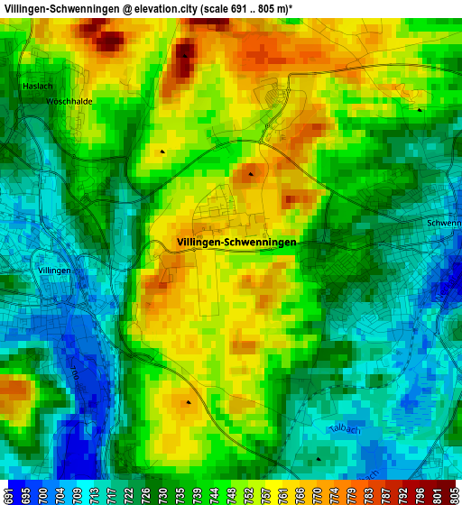
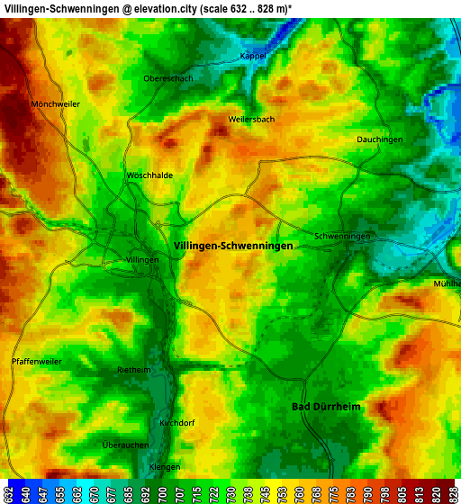
Below is the Elevation map of Villingen-Schwenningen, which displays elevation range with different colors. Scale of the first map is from 691 to 805 m (2267 to 2641 ft) with average elevation of 738.3 meters (=2422 ft) [note 1]
These maps also provides idea of topography and contour of this city, they are displayed at different zoom levels. More info about maps, scale and edge coordinates you can find below images.
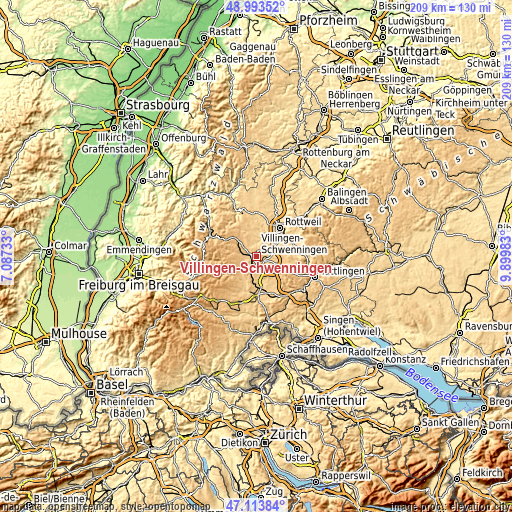
| \ | Map #1 | Map #2 | Topo.Map |
| Scale [m] | 691..805 m | 632..828 m | × |
| Scale [ft] | 2267..2641 ft | 2073..2717 ft | × |
| Average | 738.3 m = 2422 ft | 733.7 m = 2407 ft | × |
| Width | 6.53 km = 4.1 mi | 13.06 km = 8.1 mi | 209 km = 129.9 mi |
| Height | 6.53 km = 4.1 mi | 13.06 km = 8.1 mi | 209 km = 129.9 mi |
| ↑Max Latitude | 48.091621° | 48.120966° | 48.99352° |
| Latitude at center | 48.06226° | 48.06226° | 48.06226° |
| ↓Min Latitude | 48.032882° | 48.003487° | 47.11384° |
| ← Min Longitude | 8.449635° | 8.405689° | 7.08733° |
| Longitude center | 8.49358° | 8.49358° | 8.49358° |
| →Max Longitude | 8.537525° | 8.581471° | 9.89983° |
Nearby cities:
Cities around Villingen-Schwenningen sort by population:
• Donaueschingen elevation 701 m
11.9 km,  178°
178°
• Trossingen 687 m
11.3 km,  81°
81°
• Bad Dürrheim 700 m
5.4 km,  149°
149°
• Königsfeld im Schwarzwald 761 m
10.1 km,  326°
326°
• Deißlingen 601 m
10.1 km,  56°
56°
• Zimmern ob Rottweil 663 m
13.8 km,  32°
32°
• Niedereschach 659 m
8.4 km,  20°
20°
• Dauchingen 731 m
5.2 km,  53°
53°
• Mönchweiler 783 m
6.8 km,  308°
308°
• Unterkirnach 805 m
9.7 km,  281°
281°
• Tuningen 759 m
8.5 km,  112°
112°
• Talheim 827 m
13.8 km, 111°
Multilingual:
 En español:
Villingen-Schwenningen elevación 757 m.
 En France:
Villingen-Schwenningen élévation 757 m.
 Auf Deutsch:
Villingen-Schwenningen höhe über dem Meeresspiegel ist 757 m.
 На русском:
Виллинген-Швеннинген, Филлинген-Швеннинген высота над уровнем моря 757 м
Sources and notes:
- [note 1] Map square and city borders are not equal. Map elevation data is calculated only from area inside that square.
- [src 1] Elevation data from geonames database provided with same terms of usage.
- [src 2] The elevation map of Villingen-Schwenningen is generated using elevation data from NASA's 3 arcsec (90m) resolution SRTM data.
- [src 3] Base (background) map © OpenStreetMap contributors tiles are generated by Geofabrik and OpenTopoMap.
Copyright & License:
This Villingen-Schwenningen Elevation Map is licensed under CC BY-SA. You may reuse any part from this page, if you give a proper credit by linking to this URL:
 More info on terms of use page.