Vöhringen elevation
Vöhringen (Bavaria, Swabia), Germany elevation is 499 meters and Vöhringen elevation in feet is 1637 ft above sea level [src 1]. Vöhringen is a populated place (feature code) with elevation that is 241 meters (791 ft) bigger than average city elevation in Germany.
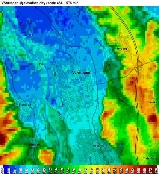
Below is the Elevation map of Vöhringen, which displays elevation range with different colors. Scale of the first map is from 484 to 576 m (1588 to 1890 ft) with average elevation of 512.9 meters (=1683 ft) [note 1]
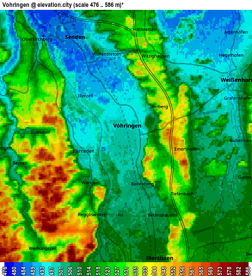
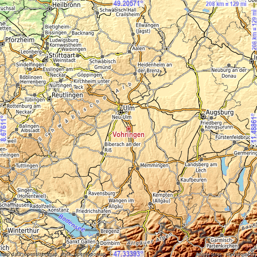
These maps also provides idea of topography and contour of this city, they are displayed at different zoom levels. More info about maps, scale and edge coordinates you can find below images.
| \ | Map #1 | Map #2 | Topo.Map |
| Scale [m] | 484..576 m | 476..586 m | × |
| Scale [ft] | 1588..1890 ft | 1562..1923 ft | × |
| Average | 512.9 m = 1683 ft | 515.7 m = 1692 ft | × |
| Width | 6.5 km = 4 mi | 13.01 km = 8.1 mi | 208.1 km = 129.3 mi |
| Height | 6.5 km = 4 mi | 13.01 km = 8.1 mi | 208.1 km = 129.3 mi |
| ↑Max Latitude | 48.307628° | 48.336849° | 49.20571° |
| Latitude at center | 48.27839° | 48.27839° | 48.27839° |
| ↓Min Latitude | 48.249135° | 48.219864° | 47.33393° |
| ← Min Longitude | 10.038415° | 9.994469° | 8.67611° |
| Longitude center | 10.08236° | 10.08236° | 10.08236° |
| →Max Longitude | 10.126305° | 10.170251° | 11.48861° |
Nearby cities:
Cities around Vöhringen sort by population:
• Senden elevation 487 m
5.8 km,  331°
331°
• Illertissen 516 m
6.3 km,  165°
165°
• Weißenhorn 503 m
6.5 km,  62°
62°
• Pfaffenhofen an der Roth 488 m
10.3 km,  34°
34°
• Dietenheim 513 m
7.6 km,  186°
186°
• Bellenberg 504 m
2.4 km,  164°
164°
• Buch 545 m
9.4 km,  129°
129°
• Illerrieden 500 m
2.5 km,  248°
248°
• Staig 499 m
7.1 km,  289°
289°
• Wain 545 m
10.9 km,  204°
204°
• Hüttisheim 510 m
10.4 km,  270°
270°
• Schnürpflingen 517 m
6.6 km,  264°
264°
Multilingual:
 En español:
Vöhringen elevación 499 m.
 En France:
Vöhringen élévation 499 m.
 Auf Deutsch:
Vöhringen höhe über dem Meeresspiegel ist 499 m.

Sources and notes:
- [note 1] Map square and city borders are not equal. Map elevation data is calculated only from area inside that square.
- [src 1] Elevation data from geonames database provided with same terms of usage.
- [src 2] The elevation map of Vöhringen is generated using elevation data from NASA's 3 arcsec (90m) resolution SRTM data.
- [src 3] Base (background) map © OpenStreetMap contributors tiles are generated by Geofabrik and OpenTopoMap.
Copyright & License:
This Vöhringen Elevation Map is licensed under CC BY-SA. You may reuse any part from this page, if you give a proper credit by linking to this URL:
 More info on terms of use page.