Weichs elevation
Weichs (Bavaria, Upper Bavaria), Germany elevation is 483 meters and Weichs elevation in feet is 1585 ft above sea level [src 1]. Weichs is a seat of a fourth-order administrative division (feature code) with elevation that is 225 meters (738 ft) bigger than average city elevation in Germany.
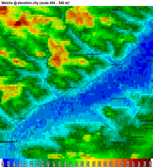
Below is the Elevation map of Weichs, which displays elevation range with different colors. Scale of the first map is from 454 to 548 m (1490 to 1798 ft) with average elevation of 483 meters (=1585 ft) [note 1]
These maps also provides idea of topography and contour of this city, they are displayed at different zoom levels. More info about maps, scale and edge coordinates you can find below images.
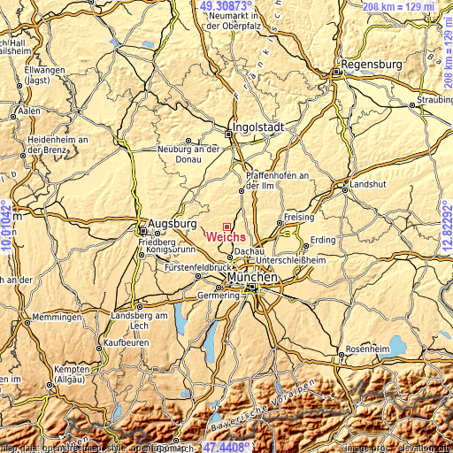
| \ | Map #1 | Topo.Map |
| Scale [m] | 454..548 m | × |
| Scale [ft] | 1490..1798 ft | × |
| Average | 483 m = 1585 ft | × |
| Width | 6.49 km = 4 mi | 207.7 km = 129.1 mi |
| Height | 6.49 km = 4 mi | 207.7 km = 129.1 mi |
| ↑Max Latitude | 48.412508° | 49.30873° |
| Latitude at center | 48.38333° | 48.38333° |
| ↓Min Latitude | 48.354136° | 47.4408° |
| ← Min Longitude | 11.372725° | 10.01042° |
| Longitude center | 11.41667° | 11.41667° |
| →Max Longitude | 11.460615° | 12.82292° |
Nearby cities:
Cities around Weichs sort by population:
• Markt Indersdorf elevation 469 m
3.8 km,  228°
228°
• Altomünster 510 m
11.8 km,  272°
272°
• Röhrmoos 494 m
6.4 km,  159°
159°
• Petershausen 463 m
4.9 km,  53°
53°
• Schwabhausen 507 m
4.8 km,  294°
294°
• Erdweg 480 m
10.1 km,  235°
235°
• Hebertshausen 480 m
11 km, 160°
• Fahrenzhausen 458 m
10.8 km,  108°
108°
• Vierkirchen 485 m
4.1 km,  116°
116°
• Hilgertshausen-Tandern 491 m
6.9 km,  318°
318°
• Jetzendorf 484 m
5.6 km,  0°
0°
• Hohenkammer 461 m
9.2 km,  60°
60°
Multilingual:
 En español:
Weichs elevación 483 m.
 En France:
Weichs élévation 483 m.


Sources and notes:
- [note 1] Map square and city borders are not equal. Map elevation data is calculated only from area inside that square.
- [src 1] Elevation data from geonames database provided with same terms of usage.
- [src 2] The elevation map of Weichs is generated using elevation data from NASA's 3 arcsec (90m) resolution SRTM data.
- [src 3] Base (background) map © OpenStreetMap contributors tiles are generated by Geofabrik and OpenTopoMap.
Copyright & License:
This Weichs Elevation Map is licensed under CC BY-SA. You may reuse any part from this page, if you give a proper credit by linking to this URL:
 More info on terms of use page.