Weidenbach elevation
Weidenbach (Bavaria, Regierungsbezirk Mittelfranken), Germany elevation is 439 meters and Weidenbach elevation in feet is 1440 ft above sea level [src 1]. Weidenbach is a populated place (feature code) with elevation that is 181 meters (594 ft) bigger than average city elevation in Germany.
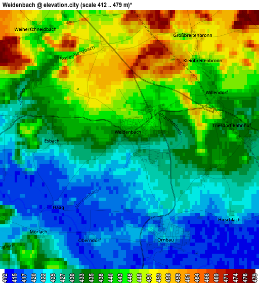
Below is the Elevation map of Weidenbach, which displays elevation range with different colors. Scale of the first map is from 412 to 479 m (1352 to 1572 ft) with average elevation of 435.2 meters (=1428 ft) [note 1]
These maps also provides idea of topography and contour of this city, they are displayed at different zoom levels. More info about maps, scale and edge coordinates you can find below images.
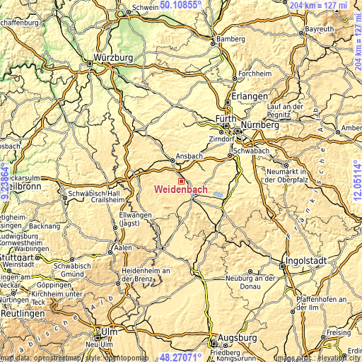
| \ | Map #1 | Topo.Map |
| Scale [m] | 412..479 m | × |
| Scale [ft] | 1352..1572 ft | × |
| Average | 435.2 m = 1428 ft | × |
| Width | 6.39 km = 4 mi | 204.3 km = 126.9 mi |
| Height | 6.39 km = 4 mi | 204.3 km = 126.9 mi |
| ↑Max Latitude | 49.226877° | 50.10855° |
| Latitude at center | 49.19817° | 49.19817° |
| ↓Min Latitude | 49.169446° | 48.27071° |
| ← Min Longitude | 10.600945° | 9.23864° |
| Longitude center | 10.64489° | 10.64489° |
| →Max Longitude | 10.688835° | 12.05114° |
Nearby cities:
Cities around Weidenbach sort by population:
• Ansbach elevation 451 m
12.4 km,  342°
342°
• Gunzenhausen 430 m
12.3 km,  137°
137°
• Herrieden 428 m
11.2 km,  293°
293°
• Burgoberbach 467 m
5.9 km,  311°
311°
• Sachsen 410 m
10.3 km,  6°
6°
• Wolframs-Eschenbach 438 m
6.8 km,  62°
62°
• Merkendorf 434 m
4.3 km,  82°
82°
• Haundorf 444 m
9.5 km,  105°
105°
• Arberg 450 m
6.3 km,  198°
198°
• Muhr am See 422 m
7.2 km,  132°
132°
• Ornbau 421 m
2.6 km,  158°
158°
• Mitteleschenbach 410 m
11.2 km, 82°
Multilingual:
 En español:
Weidenbach elevación 439 m.
 En France:
Weidenbach élévation 439 m.
 Auf Deutsch:
Weidenbach höhe über dem Meeresspiegel ist 439 m.

Sources and notes:
- [note 1] Map square and city borders are not equal. Map elevation data is calculated only from area inside that square.
- [src 1] Elevation data from geonames database provided with same terms of usage.
- [src 2] The elevation map of Weidenbach is generated using elevation data from NASA's 3 arcsec (90m) resolution SRTM data.
- [src 3] Base (background) map © OpenStreetMap contributors tiles are generated by Geofabrik and OpenTopoMap.
Copyright & License:
This Weidenbach Elevation Map is licensed under CC BY-SA. You may reuse any part from this page, if you give a proper credit by linking to this URL:
 More info on terms of use page.