Weilheim elevation
Weilheim (Bavaria, Upper Bavaria), Germany elevation is 573 meters and Weilheim elevation in feet is 1880 ft above sea level [src 1]. Weilheim is a seat of a third-order administrative division (feature code) with elevation that is 315 meters (1033 ft) bigger than average city elevation in Germany.
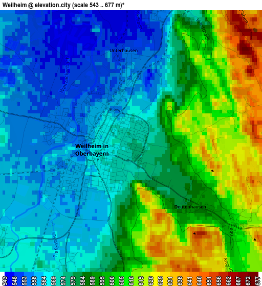
Below is the Elevation map of Weilheim, which displays elevation range with different colors. Scale of the first map is from 543 to 677 m (1781 to 2221 ft) with average elevation of 582.7 meters (=1912 ft) [note 1]
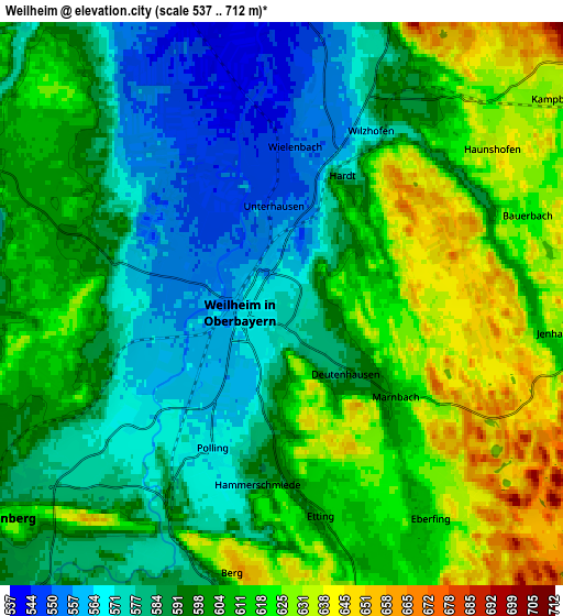
These maps also provides idea of topography and contour of this city, they are displayed at different zoom levels. More info about maps, scale and edge coordinates you can find below images.
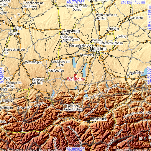
| \ | Map #1 | Map #2 | Topo.Map |
| Scale [m] | 543..677 m | 537..712 m | × |
| Scale [ft] | 1781..2221 ft | 1762..2336 ft | × |
| Average | 582.7 m = 1912 ft | 599.5 m = 1967 ft | × |
| Width | 6.56 km = 4.1 mi | 13.12 km = 8.2 mi | 209.9 km = 130.4 mi |
| Height | 6.56 km = 4.1 mi | 13.12 km = 8.2 mi | 209.9 km = 130.4 mi |
| ↑Max Latitude | 47.870957° | 47.900427° | 48.77675° |
| Latitude at center | 47.84147° | 47.84147° | 47.84147° |
| ↓Min Latitude | 47.811966° | 47.782446° | 46.88902° |
| ← Min Longitude | 11.110895° | 11.066949° | 9.74859° |
| Longitude center | 11.15484° | 11.15484° | 11.15484° |
| →Max Longitude | 11.198785° | 11.242731° | 12.56109° |
Nearby cities:
Cities around Weilheim sort by population:
• Peißenberg elevation 582 m
7.5 km,  237°
237°
• Dießen am Ammersee 548 m
12.8 km,  342°
342°
• Tutzing 595 m
12 km,  51°
51°
• Hohenpeißenberg 771 m
12.4 km,  248°
248°
• Polling 569 m
3.8 km,  206°
206°
• Seeshaupt 598 m
11.2 km,  99°
99°
• Huglfing 632 m
8.4 km,  173°
173°
• Pähl 582 m
6.8 km,  18°
18°
• Raisting 553 m
9.3 km,  333°
333°
• Oberhausen 588 m
6.7 km,  193°
193°
• Wessobrunn 698 m
10.4 km,  290°
290°
• Obersöchering 662 m
12.9 km,  158°
158°
Multilingual:
 En español:
Weilheim elevación 573 m.
 En France:
Weilheim élévation 573 m.
 Auf Deutsch:
Weilheim höhe über dem Meeresspiegel ist 573 m.
 На русском:
Вайльхайм-ин-Обербайерн высота над уровнем моря 573 м
Sources and notes:
- [note 1] Map square and city borders are not equal. Map elevation data is calculated only from area inside that square.
- [src 1] Elevation data from geonames database provided with same terms of usage.
- [src 2] The elevation map of Weilheim is generated using elevation data from NASA's 3 arcsec (90m) resolution SRTM data.
- [src 3] Base (background) map © OpenStreetMap contributors tiles are generated by Geofabrik and OpenTopoMap.
Copyright & License:
This Weilheim Elevation Map is licensed under CC BY-SA. You may reuse any part from this page, if you give a proper credit by linking to this URL:
 More info on terms of use page.