Weisen elevation
Weisen (Brandenburg), Germany elevation is 24 meters and Weisen elevation in feet is 79 ft above sea level [src 1]. Weisen is a seat of a fourth-order administrative division (feature code) with elevation that is 234 meters (768 ft) smaller than average city elevation in Germany.
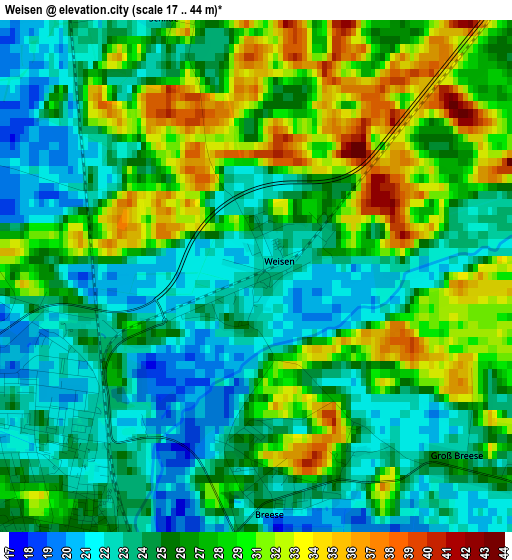
Below is the Elevation map of Weisen, which displays elevation range with different colors. Scale of the first map is from 17 to 44 m (56 to 144 ft) with average elevation of 26.8 meters (=88 ft) [note 1]
These maps also provides idea of topography and contour of this city, they are displayed at different zoom levels. More info about maps, scale and edge coordinates you can find below images.
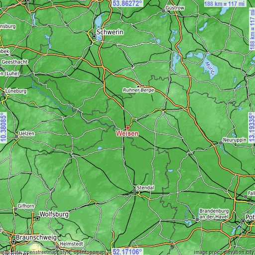
| \ | Map #1 | Topo.Map |
| Scale [m] | 17..44 m | × |
| Scale [ft] | 56..144 ft | × |
| Average | 26.8 m = 88 ft | × |
| Width | 5.88 km = 3.7 mi | 188.1 km = 116.9 mi |
| Height | 5.88 km = 3.7 mi | 188.1 km = 116.9 mi |
| ↑Max Latitude | 53.051603° | 53.86272° |
| Latitude at center | 53.02518° | 53.02518° |
| ↓Min Latitude | 52.99874° | 52.17106° |
| ← Min Longitude | 11.743155° | 10.38085° |
| Longitude center | 11.7871° | 11.7871° |
| →Max Longitude | 11.831045° | 13.19335° |
Nearby cities:
Cities around Weisen sort by population:
• Wittenberge elevation 23 m
3.3 km,  228°
228°
• Perleberg 32 m
7.3 km,  39°
39°
• Osterburg 25 m
26.6 km,  184°
184°
• Karstädt 32 m
15.5 km,  348°
348°
• Groß Pankow 57 m
20.4 km,  59°
59°
• Seehausen 22 m
15.4 km,  188°
188°
• Plattenburg 33 m
17.8 km,  114°
114°
• Luftkurort Arendsee 32 m
25.8 km, 231°
• Bad Wilsnack 27 m
13.3 km,  125°
125°
• Lenzen 21 m
22.2 km,  289°
289°
• Breese 21 m
2.9 km,  162°
162°
• Gartow 20 m
21.7 km,  269°
269°
Multilingual:
 En español:
Weisen elevación 24 m.
 En France:
Weisen élévation 24 m.


Sources and notes:
- [note 1] Map square and city borders are not equal. Map elevation data is calculated only from area inside that square.
- [src 1] Elevation data from geonames database provided with same terms of usage.
- [src 2] The elevation map of Weisen is generated using elevation data from NASA's 3 arcsec (90m) resolution SRTM data.
- [src 3] Base (background) map © OpenStreetMap contributors tiles are generated by Geofabrik and OpenTopoMap.
Copyright & License:
This Weisen Elevation Map is licensed under CC BY-SA. You may reuse any part from this page, if you give a proper credit by linking to this URL:
 More info on terms of use page.