Weisenbach elevation
Weisenbach (Baden-Württemberg, Karlsruhe Region), Germany elevation is 196 meters and Weisenbach elevation in feet is 643 ft above sea level [src 1]. Weisenbach is a seat of a fourth-order administrative division (feature code) with elevation that is 62 meters (203 ft) smaller than average city elevation in Germany.
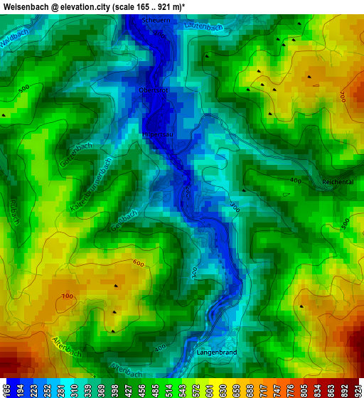
Below is the Elevation map of Weisenbach, which displays elevation range with different colors. Scale of the first map is from 165 to 921 m (541 to 3022 ft) with average elevation of 454.9 meters (=1492 ft) [note 1]
These maps also provides idea of topography and contour of this city, they are displayed at different zoom levels. More info about maps, scale and edge coordinates you can find below images.
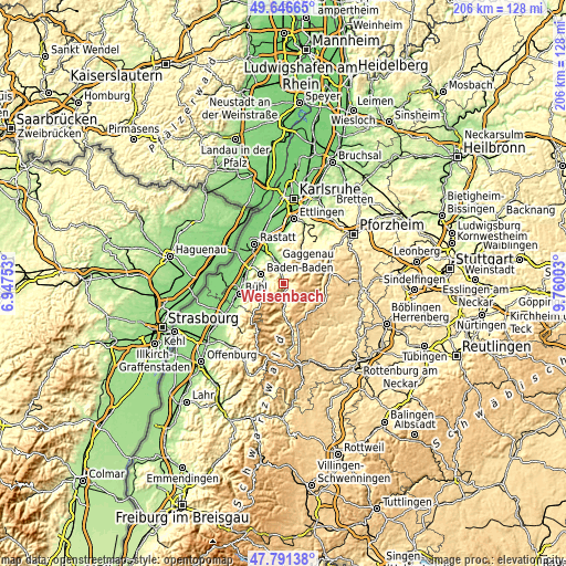
| \ | Map #1 | Topo.Map |
| Scale [m] | 165..921 m | × |
| Scale [ft] | 541..3022 ft | × |
| Average | 454.9 m = 1492 ft | × |
| Width | 6.45 km = 4 mi | 206.3 km = 128.2 mi |
| Height | 6.45 km = 4 mi | 206.3 km = 128.2 mi |
| ↑Max Latitude | 48.75655° | 49.64665° |
| Latitude at center | 48.72757° | 48.72757° |
| ↓Min Latitude | 48.698574° | 47.79138° |
| ← Min Longitude | 8.309835° | 6.94753° |
| Longitude center | 8.35378° | 8.35378° |
| →Max Longitude | 8.397725° | 9.76003° |
Nearby cities:
Cities around Weisenbach sort by population:
• Baden-Baden elevation 169 m
9.1 km,  293°
293°
• Gaggenau 186 m
8.2 km,  349°
349°
• Gernsbach 161 m
4.8 km, 350°
• Bühlertal 245 m
13 km,  248°
248°
• Kuppenheim 128 m
13.3 km,  326°
326°
• Bad Herrenalb 365 m
9.9 km,  37°
37°
• Forbach 384 m
4.9 km,  183°
183°
• Biberach 731 m
14.2 km,  203°
203°
• Bischweier 136 m
13.3 km,  337°
337°
• Loffenau 329 m
5.4 km,  24°
24°
• Dobel 707 m
13.4 km,  53°
53°
• Enzklösterle 597 m
11 km,  128°
128°
Multilingual:
 En español:
Weisenbach elevación 196 m.
 En France:
Weisenbach élévation 196 m.
 Auf Deutsch:
Weisenbach höhe über dem Meeresspiegel ist 196 m.

Sources and notes:
- [note 1] Map square and city borders are not equal. Map elevation data is calculated only from area inside that square.
- [src 1] Elevation data from geonames database provided with same terms of usage.
- [src 2] The elevation map of Weisenbach is generated using elevation data from NASA's 3 arcsec (90m) resolution SRTM data.
- [src 3] Base (background) map © OpenStreetMap contributors tiles are generated by Geofabrik and OpenTopoMap.
Copyright & License:
This Weisenbach Elevation Map is licensed under CC BY-SA. You may reuse any part from this page, if you give a proper credit by linking to this URL:
 More info on terms of use page.