Werdohl elevation
Werdohl (North Rhine-Westphalia, Regierungsbezirk Arnsberg), Germany elevation is 201 meters and Werdohl elevation in feet is 659 ft above sea level [src 1]. Werdohl is a populated place (feature code) with elevation that is 57 meters (187 ft) smaller than average city elevation in Germany.
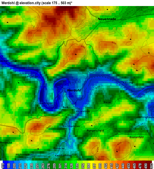
Below is the Elevation map of Werdohl, which displays elevation range with different colors. Scale of the first map is from 175 to 503 m (574 to 1650 ft) with average elevation of 321.1 meters (=1053 ft) [note 1]
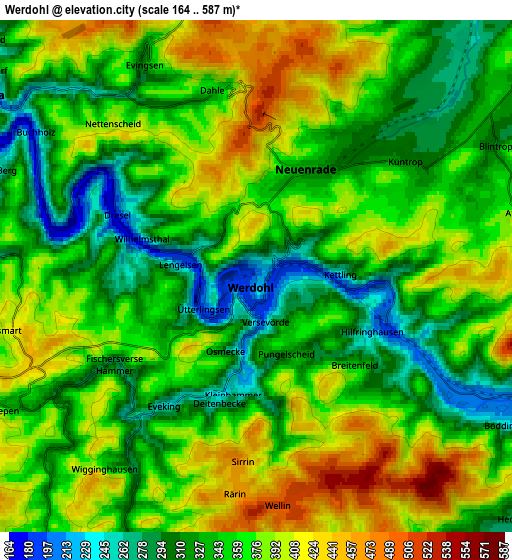
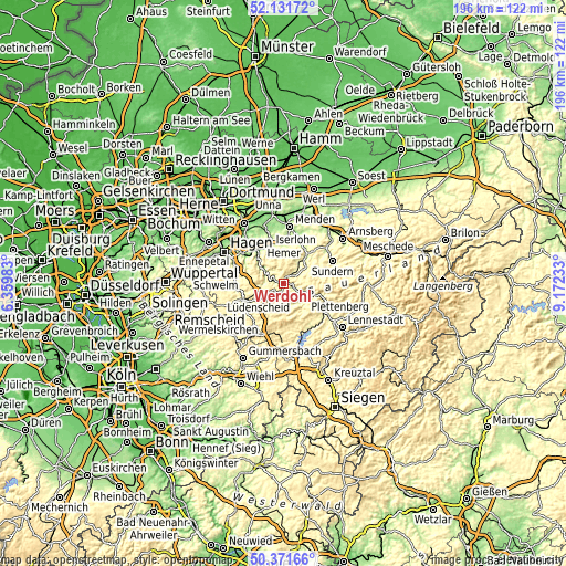
These maps also provides idea of topography and contour of this city, they are displayed at different zoom levels. More info about maps, scale and edge coordinates you can find below images.
| \ | Map #1 | Map #2 | Topo.Map |
| Scale [m] | 175..503 m | 164..587 m | × |
| Scale [ft] | 574..1650 ft | 538..1926 ft | × |
| Average | 321.1 m = 1053 ft | 358.4 m = 1176 ft | × |
| Width | 6.12 km = 3.8 mi | 12.23 km = 7.6 mi | 195.7 km = 121.6 mi |
| Height | 6.12 km = 3.8 mi | 12.23 km = 7.6 mi | 195.7 km = 121.6 mi |
| ↑Max Latitude | 51.287602° | 51.315078° | 52.13172° |
| Latitude at center | 51.26011° | 51.26011° | 51.26011° |
| ↓Min Latitude | 51.232601° | 51.205076° | 50.37166° |
| ← Min Longitude | 7.722135° | 7.678189° | 6.35983° |
| Longitude center | 7.76608° | 7.76608° | 7.76608° |
| →Max Longitude | 7.810025° | 7.853971° | 9.17233° |
Nearby cities:
Cities around Werdohl sort by population:
• Iserlohn elevation 253 m
13.6 km,  341°
341°
• Lüdenscheid 410 m
10.7 km,  245°
245°
• Hemer 215 m
14.1 km,  1°
1°
• Plettenberg 230 m
9.3 km,  127°
127°
• Attendorn 260 m
17.7 km,  147°
147°
• Altena 167 m
7.5 km,  300°
300°
• Finnentrop 251 m
17.7 km, 125°
• Neuenrade 327 m
2.8 km,  24°
24°
• Balve 237 m
10.5 km,  40°
40°
• Schalksmühle 253 m
16.7 km,  262°
262°
• Herscheid 428 m
9.2 km,  189°
189°
• Nachrodt-Wiblingwerde 419 m
12.1 km, 301°
Multilingual:
 En español:
Werdohl elevación 201 m.
 En France:
Werdohl élévation 201 m.


Sources and notes:
- [note 1] Map square and city borders are not equal. Map elevation data is calculated only from area inside that square.
- [src 1] Elevation data from geonames database provided with same terms of usage.
- [src 2] The elevation map of Werdohl is generated using elevation data from NASA's 3 arcsec (90m) resolution SRTM data.
- [src 3] Base (background) map © OpenStreetMap contributors tiles are generated by Geofabrik and OpenTopoMap.
Copyright & License:
This Werdohl Elevation Map is licensed under CC BY-SA. You may reuse any part from this page, if you give a proper credit by linking to this URL:
 More info on terms of use page.