Wiesenburg elevation
Wiesenburg (Brandenburg), Germany elevation is 172 meters and Wiesenburg elevation in feet is 564 ft above sea level [src 1]. Wiesenburg is a populated place (feature code) with elevation that is 86 meters (282 ft) smaller than average city elevation in Germany.
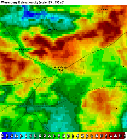
Below is the Elevation map of Wiesenburg, which displays elevation range with different colors. Scale of the first map is from 129 to 195 m (423 to 640 ft) with average elevation of 164.3 meters (=539 ft) [note 1]
These maps also provides idea of topography and contour of this city, they are displayed at different zoom levels. More info about maps, scale and edge coordinates you can find below images.
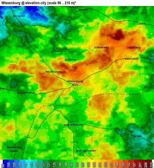
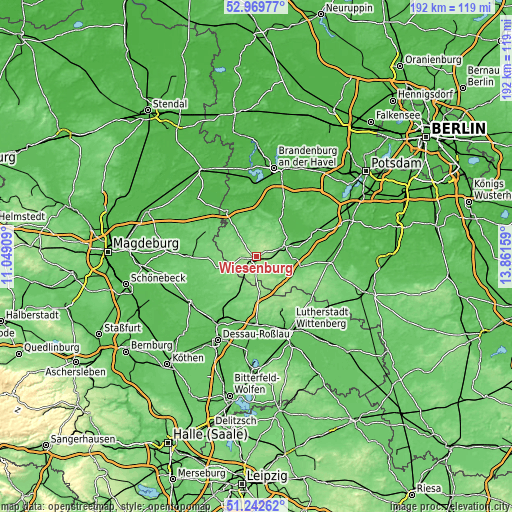
| \ | Map #1 | Map #2 | Topo.Map |
| Scale [m] | 129..195 m | 96..210 m | × |
| Scale [ft] | 423..640 ft | 315..689 ft | × |
| Average | 164.3 m = 539 ft | 153 m = 502 ft | × |
| Width | 6 km = 3.7 mi | 12 km = 7.5 mi | 192 km = 119.3 mi |
| Height | 6 km = 3.7 mi | 12 km = 7.5 mi | 192 km = 119.3 mi |
| ↑Max Latitude | 52.141538° | 52.1685° | 52.96977° |
| Latitude at center | 52.11456° | 52.11456° | 52.11456° |
| ↓Min Latitude | 52.087566° | 52.060555° | 51.24262° |
| ← Min Longitude | 12.411395° | 12.367449° | 11.04909° |
| Longitude center | 12.45534° | 12.45534° | 12.45534° |
| →Max Longitude | 12.499285° | 12.543231° | 13.86159° |
Nearby cities:
Cities around Wiesenburg sort by population:
• Bad Belzig elevation 84 m
9.9 km,  72°
72°
• Coswig 78 m
25.4 km,  180°
180°
• Brück 45 m
23.3 km, 66°
• Ziesar 54 m
20.3 km,  326°
326°
• Loburg 77 m
25.7 km,  270°
270°
• Niemegk 80 m
16.6 km,  105°
105°
• Görzke 102 m
8.4 km,  319°
319°
• Golzow 42 m
20.5 km,  28°
28°
• Dobien 92 m
25.6 km,  155°
155°
• Lindau 80 m
25.2 km,  250°
250°
• Klieken 68 m
25.8 km,  192°
192°
• Nudersdorf 109 m
22.6 km,  154°
154°
Multilingual:
 En español:
Wiesenburg elevación 172 m.
 En France:
Wiesenburg élévation 172 m.
 Auf Deutsch:
Wiesenburg höhe über dem Meeresspiegel ist 172 m.

Sources and notes:
- [note 1] Map square and city borders are not equal. Map elevation data is calculated only from area inside that square.
- [src 1] Elevation data from geonames database provided with same terms of usage.
- [src 2] The elevation map of Wiesenburg is generated using elevation data from NASA's 3 arcsec (90m) resolution SRTM data.
- [src 3] Base (background) map © OpenStreetMap contributors tiles are generated by Geofabrik and OpenTopoMap.
Copyright & License:
This Wiesenburg Elevation Map is licensed under CC BY-SA. You may reuse any part from this page, if you give a proper credit by linking to this URL:
 More info on terms of use page.