Wietzendorf elevation
Wietzendorf (Lower Saxony), Germany elevation is 64 meters and Wietzendorf elevation in feet is 210 ft above sea level [src 1]. Wietzendorf is a seat of a fourth-order administrative division (feature code) with elevation that is 194 meters (636 ft) smaller than average city elevation in Germany.
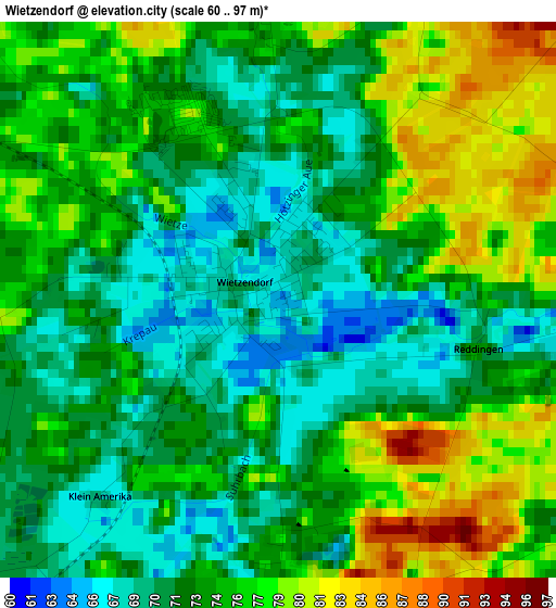
Below is the Elevation map of Wietzendorf, which displays elevation range with different colors. Scale of the first map is from 60 to 97 m (197 to 318 ft) with average elevation of 73.9 meters (=242 ft) [note 1]
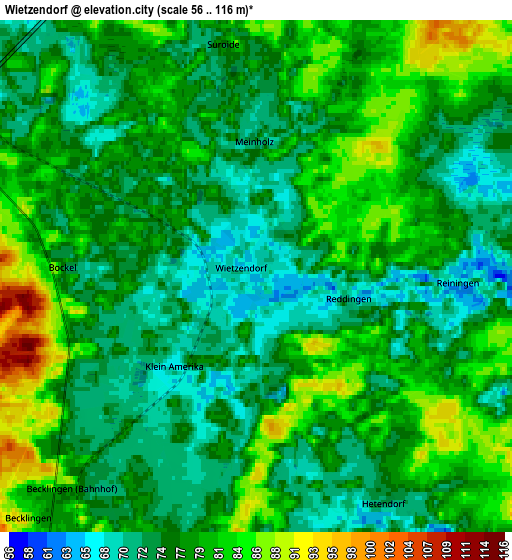
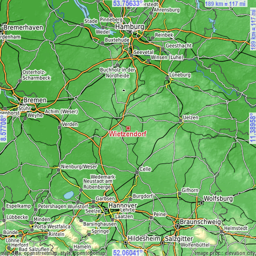
These maps also provides idea of topography and contour of this city, they are displayed at different zoom levels. More info about maps, scale and edge coordinates you can find below images.
| \ | Map #1 | Map #2 | Topo.Map |
| Scale [m] | 60..97 m | 56..116 m | × |
| Scale [ft] | 197..318 ft | 184..381 ft | × |
| Average | 73.9 m = 242 ft | 77.3 m = 254 ft | × |
| Width | 5.89 km = 3.7 mi | 11.79 km = 7.3 mi | 188.6 km = 117.2 mi |
| Height | 5.89 km = 3.7 mi | 11.79 km = 7.3 mi | 188.6 km = 117.2 mi |
| ↑Max Latitude | 52.94316° | 52.969634° | 53.75633° |
| Latitude at center | 52.91667° | 52.91667° | 52.91667° |
| ↓Min Latitude | 52.890164° | 52.863642° | 52.06041° |
| ← Min Longitude | 9.939385° | 9.895439° | 8.57708° |
| Longitude center | 9.98333° | 9.98333° | 9.98333° |
| →Max Longitude | 10.027275° | 10.071221° | 11.38958° |
Nearby cities:
Cities around Wietzendorf sort by population:
• Soltau elevation 62 m
12.2 km,  309°
309°
• Munster 79 m
10.4 km,  42°
42°
• Bergen 70 m
12.1 km,  186°
186°
• Bad Fallingbostel 39 m
20.1 km,  253°
253°
• Hermannsburg 55 m
11.8 km,  142°
142°
• Faßberg 67 m
12.4 km,  98°
98°
• Bomlitz 68 m
22.4 km,  265°
265°
• Bispingen 78 m
18.5 km,  2°
2°
• Neuenkirchen 68 m
22.6 km,  304°
304°
• Unterlüß 104 m
22.9 km,  113°
113°
• Wriedel 76 m
24.7 km,  58°
58°
• Eimke 66 m
22.8 km,  76°
76°
Multilingual:
 En español:
Wietzendorf elevación 64 m.
 En France:
Wietzendorf élévation 64 m.
 Auf Deutsch:
Wietzendorf höhe über dem Meeresspiegel ist 64 m.

Sources and notes:
- [note 1] Map square and city borders are not equal. Map elevation data is calculated only from area inside that square.
- [src 1] Elevation data from geonames database provided with same terms of usage.
- [src 2] The elevation map of Wietzendorf is generated using elevation data from NASA's 3 arcsec (90m) resolution SRTM data.
- [src 3] Base (background) map © OpenStreetMap contributors tiles are generated by Geofabrik and OpenTopoMap.
Copyright & License:
This Wietzendorf Elevation Map is licensed under CC BY-SA. You may reuse any part from this page, if you give a proper credit by linking to this URL:
 More info on terms of use page.