Wörth am Main elevation
Wörth am Main (Bavaria, Regierungsbezirk Unterfranken), Germany elevation is 124 meters and Wörth am Main elevation in feet is 407 ft above sea level [src 1]. Wörth am Main is a populated place (feature code) with elevation that is 134 meters (440 ft) smaller than average city elevation in Germany.
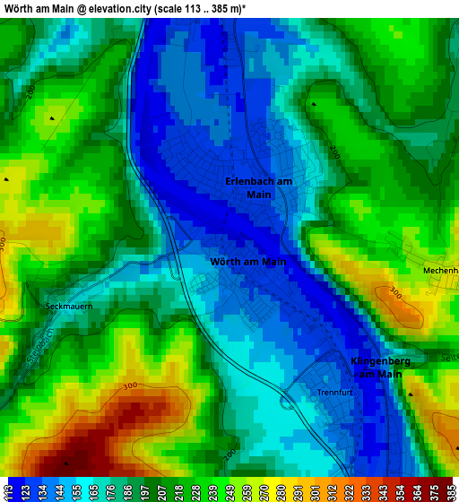
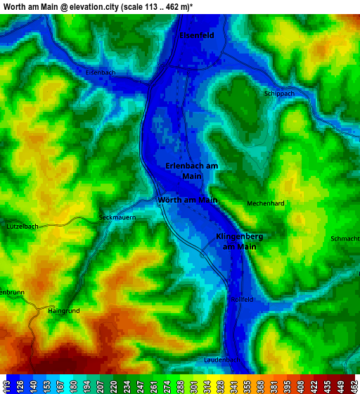
Below is the Elevation map of Wörth am Main, which displays elevation range with different colors. Scale of the first map is from 113 to 385 m (371 to 1263 ft) with average elevation of 199 meters (=653 ft) [note 1]
These maps also provides idea of topography and contour of this city, they are displayed at different zoom levels. More info about maps, scale and edge coordinates you can find below images.
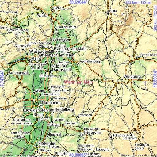
| \ | Map #1 | Map #2 | Topo.Map |
| Scale [m] | 113..385 m | 113..462 m | × |
| Scale [ft] | 371..1263 ft | 371..1516 ft | × |
| Average | 199 m = 653 ft | 241.9 m = 794 ft | × |
| Width | 6.31 km = 3.9 mi | 12.62 km = 7.8 mi | 201.9 km = 125.5 mi |
| Height | 6.31 km = 3.9 mi | 12.62 km = 7.8 mi | 201.8 km = 125.4 mi |
| ↑Max Latitude | 49.825558° | 49.8539° | 50.69644° |
| Latitude at center | 49.7972° | 49.7972° | 49.7972° |
| ↓Min Latitude | 49.768825° | 49.740434° | 48.88095° |
| ← Min Longitude | 9.109945° | 9.065999° | 7.74764° |
| Longitude center | 9.15389° | 9.15389° | 9.15389° |
| →Max Longitude | 9.197835° | 9.241781° | 10.56014° |
Nearby cities:
Cities around Wörth am Main sort by population:
• Erlenbach am Main elevation 138 m
1 km,  43°
43°
• Obernburg am Main 181 m
4.6 km,  339°
339°
• Elsenfeld 125 m
5.1 km,  7°
7°
• Klingenberg am Main 125 m
2.3 km,  125°
125°
• Kleinwallstadt 124 m
8.7 km, 7°
• Großheubach 133 m
9.1 km,  147°
147°
• Mömlingen 148 m
8.6 km,  323°
323°
• Eschau 177 m
7.9 km,  72°
72°
• Mönchberg 259 m
8.2 km,  93°
93°
• Hausen 185 m
9 km,  26°
26°
• Röllbach 218 m
7.1 km,  112°
112°
• Laudenbach 133 m
5.9 km,  164°
164°
Multilingual:
 En español:
Wörth am Main elevación 124 m.
 En France:
Wörth am Main élévation 124 m.
 Auf Deutsch:
Wörth am Main höhe über dem Meeresspiegel ist 124 m.

Sources and notes:
- [note 1] Map square and city borders are not equal. Map elevation data is calculated only from area inside that square.
- [src 1] Elevation data from geonames database provided with same terms of usage.
- [src 2] The elevation map of Wörth am Main is generated using elevation data from NASA's 3 arcsec (90m) resolution SRTM data.
- [src 3] Base (background) map © OpenStreetMap contributors tiles are generated by Geofabrik and OpenTopoMap.
Copyright & License:
This Wörth am Main Elevation Map is licensed under CC BY-SA. You may reuse any part from this page, if you give a proper credit by linking to this URL:
 More info on terms of use page.