Wulfen elevation
Wulfen (Saxony-Anhalt), Germany elevation is 69 meters and Wulfen elevation in feet is 226 ft above sea level [src 1]. Wulfen is a populated place (feature code) with elevation that is 189 meters (620 ft) smaller than average city elevation in Germany.
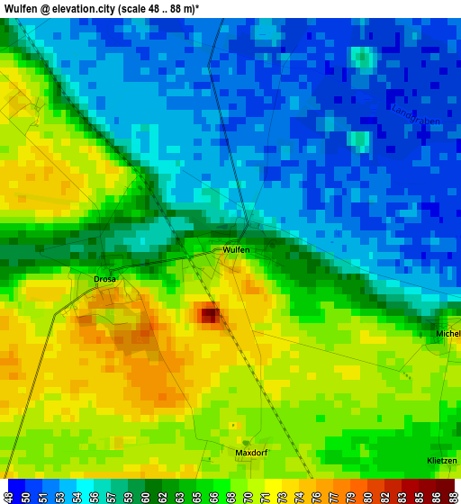
Below is the Elevation map of Wulfen, which displays elevation range with different colors. Scale of the first map is from 48 to 88 m (157 to 289 ft) with average elevation of 62.4 meters (=205 ft) [note 1]
These maps also provides idea of topography and contour of this city, they are displayed at different zoom levels. More info about maps, scale and edge coordinates you can find below images.
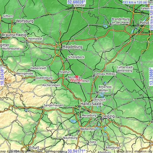
| \ | Map #1 | Topo.Map |
| Scale [m] | 48..88 m | × |
| Scale [ft] | 157..289 ft | × |
| Average | 62.4 m = 205 ft | × |
| Width | 6.04 km = 3.8 mi | 193.3 km = 120.1 mi |
| Height | 6.04 km = 3.8 mi | 193.3 km = 120.1 mi |
| ↑Max Latitude | 51.846536° | 52.68028° |
| Latitude at center | 51.81938° | 51.81938° |
| ↓Min Latitude | 51.792207° | 50.94171° |
| ← Min Longitude | 11.886685° | 10.52438° |
| Longitude center | 11.93063° | 11.93063° |
| →Max Longitude | 11.974575° | 13.33688° |
Nearby cities:
Cities around Wulfen sort by population:
• Bernburg elevation 86 m
13.4 km,  258°
258°
• Köthen 83 m
8 km,  159°
159°
• Calbe 58 m
14.4 km,  312°
312°
• Aken 55 m
8.7 km,  64°
64°
• Osternienburger Land 64 m
6.3 km,  110°
110°
• Nienburg/Saale 69 m
11.2 km,  280°
280°
• Osternienburg 72 m
7.2 km, 113°
• Groß Rosenburg 53 m
11.2 km,  346°
346°
• Baalberge 67 m
10.9 km,  236°
236°
• Peißen 69 m
14.6 km,  234°
234°
• Edderitz 89 m
13.4 km,  178°
178°
• Quellendorf 80 m
15.7 km,  119°
119°
Multilingual:
 En español:
Wulfen elevación 69 m.
 En France:
Wulfen élévation 69 m.


Sources and notes:
- [note 1] Map square and city borders are not equal. Map elevation data is calculated only from area inside that square.
- [src 1] Elevation data from geonames database provided with same terms of usage.
- [src 2] The elevation map of Wulfen is generated using elevation data from NASA's 3 arcsec (90m) resolution SRTM data.
- [src 3] Base (background) map © OpenStreetMap contributors tiles are generated by Geofabrik and OpenTopoMap.
Copyright & License:
This Wulfen Elevation Map is licensed under CC BY-SA. You may reuse any part from this page, if you give a proper credit by linking to this URL:
 More info on terms of use page.