Würselen elevation
Würselen (North Rhine-Westphalia, Regierungsbezirk Köln), Germany elevation is 190 meters and Würselen elevation in feet is 623 ft above sea level [src 1]. Würselen is a populated place (feature code) with elevation that is 68 meters (223 ft) smaller than average city elevation in Germany.
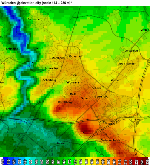
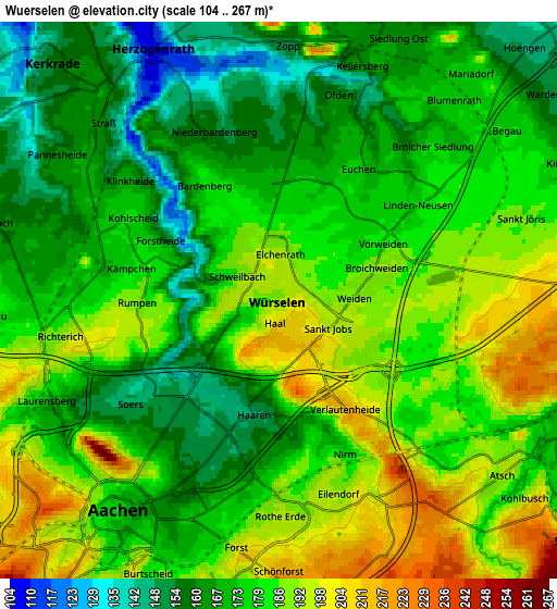
Below is the Elevation map of Würselen, which displays elevation range with different colors. Scale of the first map is from 114 to 236 m (374 to 774 ft) with average elevation of 177.4 meters (=582 ft) [note 1]
These maps also provides idea of topography and contour of this city, they are displayed at different zoom levels. More info about maps, scale and edge coordinates you can find below images.
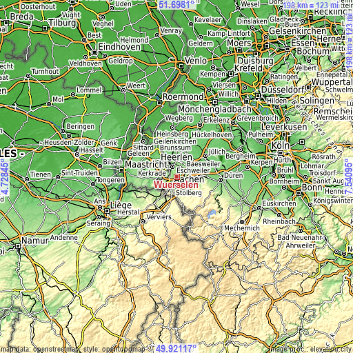
| \ | Map #1 | Map #2 | Topo.Map |
| Scale [m] | 114..236 m | 104..267 m | × |
| Scale [ft] | 374..774 ft | 341..876 ft | × |
| Average | 177.4 m = 582 ft | 178 m = 584 ft | × |
| Width | 6.17 km = 3.8 mi | 12.35 km = 7.7 mi | 197.6 km = 122.8 mi |
| Height | 6.17 km = 3.8 mi | 12.35 km = 7.7 mi | 197.6 km = 122.8 mi |
| ↑Max Latitude | 50.845846° | 50.873585° | 51.6981° |
| Latitude at center | 50.81809° | 50.81809° | 50.81809° |
| ↓Min Latitude | 50.790318° | 50.762529° | 49.92117° |
| ← Min Longitude | 6.090755° | 6.046809° | 4.72845° |
| Longitude center | 6.1347° | 6.1347° | 6.1347° |
| →Max Longitude | 6.178645° | 6.222591° | 7.54095° |
Nearby cities:
Cities around Würselen sort by population:
• Aachen elevation 178 m
5.9 km,  218°
218°
• Stolberg 185 m
8.1 km,  127°
127°
• Eschweiler 142 m
9.6 km,  89°
89°
• Herzogenrath 106 m
6.3 km,  332°
332°
• Alsdorf 167 m
6.8 km,  17°
17°
• Baesweiler 117 m
10.9 km, 20°
• Übach-Palenberg 121 m
11.1 km,  355°
355°
• Langerwehe 157 m
15.1 km, 90°
• Aldenhoven 111 m
13.8 km,  48°
48°
• Siersdorf 125 m
11 km,  35°
35°
• Neu-Pattern 120 m
12.7 km, 51°
• Niedermerz 121 m
11.6 km, 52°
Multilingual:
 En español:
Würselen elevación 190 m.
 En France:
Würselen élévation 190 m.
 Auf Deutsch:
Würselen höhe über dem Meeresspiegel ist 190 m.

Sources and notes:
- [note 1] Map square and city borders are not equal. Map elevation data is calculated only from area inside that square.
- [src 1] Elevation data from geonames database provided with same terms of usage.
- [src 2] The elevation map of Würselen is generated using elevation data from NASA's 3 arcsec (90m) resolution SRTM data.
- [src 3] Base (background) map © OpenStreetMap contributors tiles are generated by Geofabrik and OpenTopoMap.
Copyright & License:
This Würselen Elevation Map is licensed under CC BY-SA. You may reuse any part from this page, if you give a proper credit by linking to this URL:
 More info on terms of use page.