Zorneding elevation
Zorneding (Bavaria, Upper Bavaria), Germany elevation is 563 meters and Zorneding elevation in feet is 1847 ft above sea level [src 1]. Zorneding is a seat of a fourth-order administrative division (feature code) with elevation that is 305 meters (1001 ft) bigger than average city elevation in Germany.
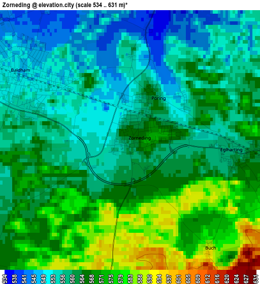
Below is the Elevation map of Zorneding, which displays elevation range with different colors. Scale of the first map is from 534 to 631 m (1752 to 2070 ft) with average elevation of 563.1 meters (=1847 ft) [note 1]
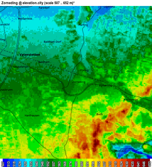
These maps also provides idea of topography and contour of this city, they are displayed at different zoom levels. More info about maps, scale and edge coordinates you can find below images.
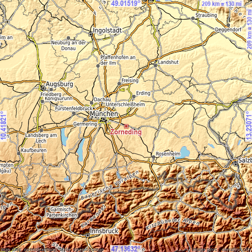
| \ | Map #1 | Map #2 | Topo.Map |
| Scale [m] | 534..631 m | 507..652 m | × |
| Scale [ft] | 1752..2070 ft | 1663..2139 ft | × |
| Average | 563.1 m = 1847 ft | 562.1 m = 1844 ft | × |
| Width | 6.53 km = 4.1 mi | 13.06 km = 8.1 mi | 208.9 km = 129.8 mi |
| Height | 6.53 km = 4.1 mi | 13.06 km = 8.1 mi | 208.9 km = 129.8 mi |
| ↑Max Latitude | 48.113679° | 48.143011° | 49.01519° |
| Latitude at center | 48.08433° | 48.08433° | 48.08433° |
| ↓Min Latitude | 48.054965° | 48.025582° | 47.13632° |
| ← Min Longitude | 11.780515° | 11.736569° | 10.41821° |
| Longitude center | 11.82446° | 11.82446° | 11.82446° |
| →Max Longitude | 11.868405° | 11.912351° | 13.23071° |
Nearby cities:
Cities around Zorneding sort by population:
• Vaterstetten elevation 547 m
4.8 km,  299°
299°
• Haar 545 m
7.8 km,  290°
290°
• Poing 519 m
9.5 km,  357°
357°
• Kirchseeon 564 m
5 km,  106°
106°
• Hohenbrunn 571 m
9.9 km,  245°
245°
• Putzbrunn 556 m
8.1 km,  263°
263°
• Grasbrunn 555 m
6 km, 264°
• Anzing 518 m
7.8 km,  15°
15°
• Oberpframmern 615 m
7 km,  186°
186°
• Egmating 612 m
9.2 km, 193°
• Moosach 530 m
6.9 km,  147°
147°
• Bruck 510 m
9.4 km,  138°
138°
Multilingual:
 En español:
Zorneding elevación 563 m.
 En France:
Zorneding élévation 563 m.
 Auf Deutsch:
Zorneding höhe über dem Meeresspiegel ist 563 m.

Sources and notes:
- [note 1] Map square and city borders are not equal. Map elevation data is calculated only from area inside that square.
- [src 1] Elevation data from geonames database provided with same terms of usage.
- [src 2] The elevation map of Zorneding is generated using elevation data from NASA's 3 arcsec (90m) resolution SRTM data.
- [src 3] Base (background) map © OpenStreetMap contributors tiles are generated by Geofabrik and OpenTopoMap.
Copyright & License:
This Zorneding Elevation Map is licensed under CC BY-SA. You may reuse any part from this page, if you give a proper credit by linking to this URL:
 More info on terms of use page.