Zulpich elevation
Zulpich (North Rhine-Westphalia, Regierungsbezirk Köln), Germany elevation is 174 meters and Zulpich elevation in feet is 571 ft above sea level [src 1]. Zulpich is a populated place (feature code) with elevation that is 84 meters (276 ft) smaller than average city elevation in Germany.
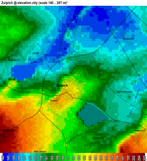
Below is the Elevation map of Zulpich, which displays elevation range with different colors. Scale of the first map is from 140 to 207 m (459 to 679 ft) with average elevation of 162.9 meters (=534 ft) [note 1]
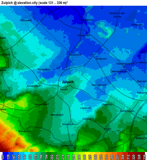
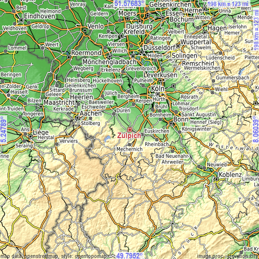
These maps also provides idea of topography and contour of this city, they are displayed at different zoom levels. More info about maps, scale and edge coordinates you can find below images.
| \ | Map #1 | Map #2 | Topo.Map |
| Scale [m] | 140..207 m | 131..336 m | × |
| Scale [ft] | 459..679 ft | 430..1102 ft | × |
| Average | 162.9 m = 534 ft | 173.6 m = 570 ft | × |
| Width | 6.19 km = 3.8 mi | 12.38 km = 7.7 mi | 198.1 km = 123.1 mi |
| Height | 6.19 km = 3.8 mi | 12.38 km = 7.7 mi | 198.1 km = 123.1 mi |
| ↑Max Latitude | 50.722299° | 50.750112° | 51.57683° |
| Latitude at center | 50.69447° | 50.69447° | 50.69447° |
| ↓Min Latitude | 50.666624° | 50.638762° | 49.7952° |
| ← Min Longitude | 6.610195° | 6.566249° | 5.24789° |
| Longitude center | 6.65414° | 6.65414° | 6.65414° |
| →Max Longitude | 6.698085° | 6.742031° | 8.06039° |
Nearby cities:
Cities around Zulpich sort by population:
• Düren elevation 142 m
16.7 km,  317°
317°
• Euskirchen 164 m
10.1 km,  111°
111°
• Erftstadt 94 m
16.6 km,  36°
36°
• Mechernich 301 m
11.3 km,  180°
180°
• Bad Münstereifel 283 m
17.2 km,  153°
153°
• Kreuzau 148 m
12.9 km,  296°
296°
• Weilerswist 120 m
15 km,  64°
64°
• Kall 384 m
18.1 km,  200°
200°
• Nörvenich 119 m
12.4 km,  355°
355°
• Nideggen 301 m
12 km,  269°
269°
• Vettweiß 161 m
5.8 km, 318°
• Heimbach 224 m
14.5 km,  243°
243°
Multilingual:
 En español:
Zulpich elevación 174 m.
 En France:
Tolbiac élévation 174 m.


Sources and notes:
- [note 1] Map square and city borders are not equal. Map elevation data is calculated only from area inside that square.
- [src 1] Elevation data from geonames database provided with same terms of usage.
- [src 2] The elevation map of Zulpich is generated using elevation data from NASA's 3 arcsec (90m) resolution SRTM data.
- [src 3] Base (background) map © OpenStreetMap contributors tiles are generated by Geofabrik and OpenTopoMap.
Copyright & License:
This Zulpich Elevation Map is licensed under CC BY-SA. You may reuse any part from this page, if you give a proper credit by linking to this URL:
 More info on terms of use page.