Bezdružice elevation
Bezdružice (Plzeňský kraj, Okres Tachov), Czech Republic elevation is 592 meters and Bezdružice elevation in feet is 1942 ft above sea level [src 1]. Bezdružice is a populated place (feature code) with elevation that is 247 meters (810 ft) bigger than average city elevation in Czech Republic.
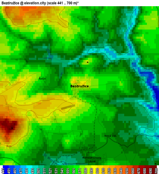
Below is the Elevation map of Bezdružice, which displays elevation range with different colors. Scale of the first map is from 441 to 700 m (1447 to 2297 ft) with average elevation of 551.2 meters (=1808 ft) [note 1]
These maps also provides idea of topography and contour of this city, they are displayed at different zoom levels. More info about maps, scale and edge coordinates you can find below images.
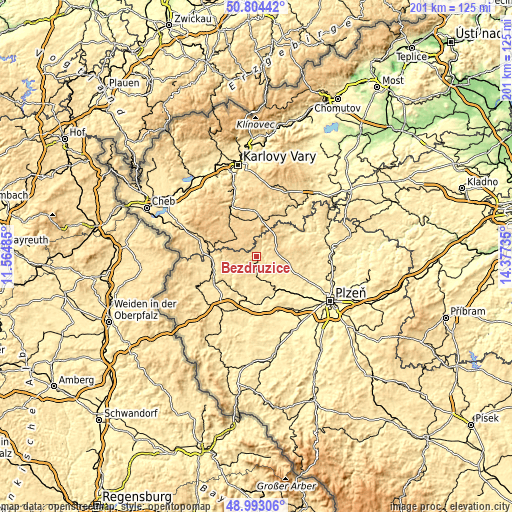
| \ | Map #1 | Topo.Map |
| Scale [m] | 441..700 m | × |
| Scale [ft] | 1447..2297 ft | × |
| Average | 551.2 m = 1808 ft | × |
| Width | 6.29 km = 3.9 mi | 201.4 km = 125.1 mi |
| Height | 6.29 km = 3.9 mi | 201.4 km = 125.1 mi |
| ↑Max Latitude | 49.935534° | 50.80442° |
| Latitude at center | 49.90724° | 49.90724° |
| ↓Min Latitude | 49.87893° | 48.99306° |
| ← Min Longitude | 12.927155° | 11.56485° |
| Longitude center | 12.9711° | 12.9711° |
| →Max Longitude | 13.015045° | 14.37735° |
Nearby cities:
Cities around Bezdružice sort by population:
• Mariánské Lázně elevation 592 m
20.3 km,  288°
288°
• Stříbro 402 m
17 km,  173°
173°
• Planá 514 m
16.9 km,  255°
255°
• Toužim 615 m
17.1 km,  3°
3°
• Klášter 660 m
9.5 km,  314°
314°
• Město 659 m
11.1 km,  316°
316°
• Velká Hleďsebe 558 m
22.5 km, 285°
• Chodová Planá 525 m
17.3 km, 264°
• Kladruby 411 m
21.4 km,  177°
177°
• Manětín 412 m
21 km,  63°
63°
• Černošín 498 m
11.9 km,  211°
211°
• Všeruby 427 m
19.9 km,  111°
111°
Multilingual:
 En español:
Bezdružice elevación 592 m.
 En France:
Bezdružice élévation 592 m.
 Auf Deutsch:
Bezdružice höhe über dem Meeresspiegel ist 592 m.

Sources and notes:
- [note 1] Map square and city borders are not equal. Map elevation data is calculated only from area inside that square.
- [src 1] Elevation data from geonames database provided with same terms of usage.
- [src 2] The elevation map of Bezdružice is generated using elevation data from NASA's 3 arcsec (90m) resolution SRTM data.
- [src 3] Base (background) map © OpenStreetMap contributors tiles are generated by Geofabrik and OpenTopoMap.
Copyright & License:
This Bezdružice Elevation Map is licensed under CC BY-SA. You may reuse any part from this page, if you give a proper credit by linking to this URL:
 More info on terms of use page.