Brandýs nad Labem-Stará Boleslav elevation
Brandýs nad Labem-Stará Boleslav (Central Bohemia, Okres Praha-východ), Czech Republic elevation is 186 meters and Brandýs nad Labem-Stará Boleslav elevation in feet is 610 ft above sea level [src 1]. Brandýs nad Labem-Stará Boleslav is a populated place (feature code) with elevation that is 159 meters (522 ft) smaller than average city elevation in Czech Republic.
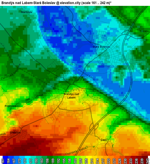
Below is the Elevation map of Brandýs nad Labem-Stará Boleslav, which displays elevation range with different colors. Scale of the first map is from 161 to 242 m (528 to 794 ft) with average elevation of 193.3 meters (=634 ft) [note 1]
These maps also provides idea of topography and contour of this city, they are displayed at different zoom levels. More info about maps, scale and edge coordinates you can find below images.
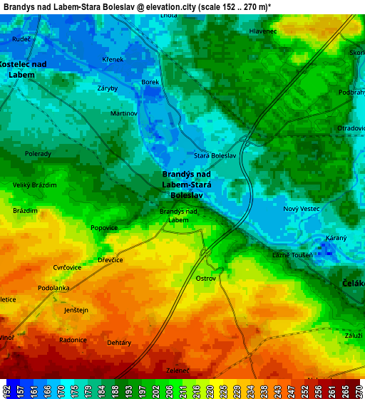
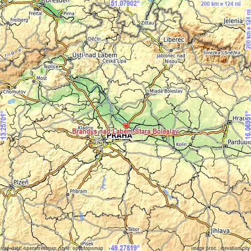
| \ | Map #1 | Map #2 | Topo.Map |
| Scale [m] | 161..242 m | 152..270 m | × |
| Scale [ft] | 528..794 ft | 499..886 ft | × |
| Average | 193.3 m = 634 ft | 202.5 m = 664 ft | × |
| Width | 6.26 km = 3.9 mi | 12.51 km = 7.8 mi | 200.2 km = 124.4 mi |
| Height | 6.26 km = 3.9 mi | 12.51 km = 7.8 mi | 200.2 km = 124.4 mi |
| ↑Max Latitude | 50.215219° | 50.243332° | 51.07902° |
| Latitude at center | 50.18709° | 50.18709° | 50.18709° |
| ↓Min Latitude | 50.158944° | 50.130782° | 49.27819° |
| ← Min Longitude | 14.619315° | 14.575369° | 13.25701° |
| Longitude center | 14.66326° | 14.66326° | 14.66326° |
| →Max Longitude | 14.707205° | 14.751151° | 16.06951° |
Nearby cities:
Cities around Brandýs nad Labem-Stará Boleslav sort by population:
• Černý Most elevation 252 m
10.9 km,  213°
213°
• Horní Počernice 286 m
9.2 km,  204°
204°
• Čelákovice 181 m
6.9 km,  115°
115°
• Kbely 272 m
10 km,  233°
233°
• Kostelec nad Labem 172 m
7.1 km,  308°
308°
• Satalice 280 m
9.5 km,  223°
223°
• Zeleneč 257 m
5.9 km,  181°
181°
• Šestajovice 261 m
8.8 km,  172°
172°
• Jirny 249 m
8.3 km,  162°
162°
• Hovorčovice 231 m
10.4 km,  264°
264°
• Měšice 202 m
10.3 km,  276°
276°
• Nehvizdy 242 m
7.9 km,  142°
142°
Multilingual:
 En español:
Brandýs nad Labem-Stará Boleslav elevación 186 m.
 En France:
Brandýs nad Labem-Stará Boleslav élévation 186 m.
 Auf Deutsch:
Brandýs nad Labem-Stará Boleslav höhe über dem Meeresspiegel ist 186 m.
 На русском:
Брандис-над-Лабем-Стара-Болеслав высота над уровнем моря 186 м
Sources and notes:
- [note 1] Map square and city borders are not equal. Map elevation data is calculated only from area inside that square.
- [src 1] Elevation data from geonames database provided with same terms of usage.
- [src 2] The elevation map of Brandýs nad Labem-Stará Boleslav is generated using elevation data from NASA's 3 arcsec (90m) resolution SRTM data.
- [src 3] Base (background) map © OpenStreetMap contributors tiles are generated by Geofabrik and OpenTopoMap.
Copyright & License:
This Brandýs nad Labem-Stará Boleslav Elevation Map is licensed under CC BY-SA. You may reuse any part from this page, if you give a proper credit by linking to this URL:
 More info on terms of use page.