Měšice elevation
Měšice (Central Bohemia, Okres Praha-východ), Czech Republic elevation is 202 meters and Měšice elevation in feet is 663 ft above sea level [src 1]. Měšice is a populated place (feature code) with elevation that is 143 meters (469 ft) smaller than average city elevation in Czech Republic.
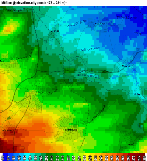
Below is the Elevation map of Měšice, which displays elevation range with different colors. Scale of the first map is from 173 to 281 m (568 to 922 ft) with average elevation of 212.6 meters (=698 ft) [note 1]
These maps also provides idea of topography and contour of this city, they are displayed at different zoom levels. More info about maps, scale and edge coordinates you can find below images.
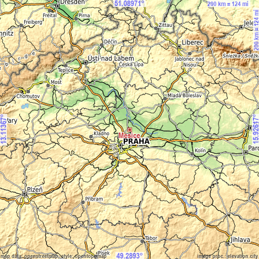
| \ | Map #1 | Topo.Map |
| Scale [m] | 173..281 m | × |
| Scale [ft] | 568..922 ft | × |
| Average | 212.6 m = 698 ft | × |
| Width | 6.26 km = 3.9 mi | 200.2 km = 124.4 mi |
| Height | 6.26 km = 3.9 mi | 200.2 km = 124.4 mi |
| ↑Max Latitude | 50.226113° | 51.08971° |
| Latitude at center | 50.19799° | 50.19799° |
| ↓Min Latitude | 50.169851° | 49.2893° |
| ← Min Longitude | 14.475975° | 13.11367° |
| Longitude center | 14.51992° | 14.51992° |
| →Max Longitude | 14.563865° | 15.92617° |
Nearby cities:
Cities around Měšice sort by population:
• Neratovice elevation 170 m
6.8 km,  358°
358°
• Letňany 276 m
7.2 km,  181°
181°
• Střížkov 296 m
8.1 km,  193°
193°
• Kbely 272 m
7.5 km,  163°
163°
• Odolena Voda 247 m
8.7 km,  296°
296°
• Kostelec nad Labem 172 m
5.6 km,  55°
55°
• Klecany 249 m
8.1 km,  252°
252°
• Libiš 165 m
8.6 km,  351°
351°
• Tišice 165 m
8.3 km,  16°
16°
• Zdiby 292 m
5.9 km,  235°
235°
• Líbeznice 233 m
2 km, 250°
• Hovorčovice 231 m
2.2 km, 183°
Multilingual:
 En español:
Měšice elevación 202 m.
 En France:
Měšice élévation 202 m.


Sources and notes:
- [note 1] Map square and city borders are not equal. Map elevation data is calculated only from area inside that square.
- [src 1] Elevation data from geonames database provided with same terms of usage.
- [src 2] The elevation map of Měšice is generated using elevation data from NASA's 3 arcsec (90m) resolution SRTM data.
- [src 3] Base (background) map © OpenStreetMap contributors tiles are generated by Geofabrik and OpenTopoMap.
Copyright & License:
This Měšice Elevation Map is licensed under CC BY-SA. You may reuse any part from this page, if you give a proper credit by linking to this URL:
 More info on terms of use page.