Chotěbuz elevation
Chotěbuz (Moravskoslezský, Okres Karviná), Czech Republic elevation is 348 meters and Chotěbuz elevation in feet is 1142 ft above sea level [src 1]. Chotěbuz is a populated place (feature code) with elevation that is 3 meters (10 ft) bigger than average city elevation in Czech Republic.
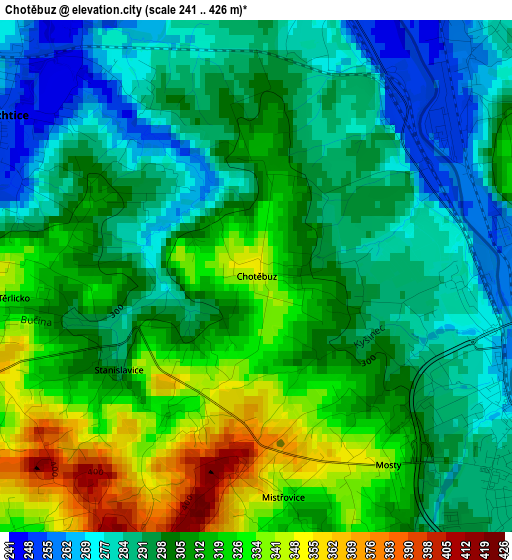
Below is the Elevation map of Chotěbuz, which displays elevation range with different colors. Scale of the first map is from 241 to 426 m (791 to 1398 ft) with average elevation of 303.8 meters (=997 ft) [note 1]
These maps also provides idea of topography and contour of this city, they are displayed at different zoom levels. More info about maps, scale and edge coordinates you can find below images.
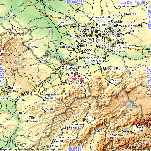
| \ | Map #1 | Topo.Map |
| Scale [m] | 241..426 m | × |
| Scale [ft] | 791..1398 ft | × |
| Average | 303.8 m = 997 ft | × |
| Width | 6.31 km = 3.9 mi | 202 km = 125.5 mi |
| Height | 6.31 km = 3.9 mi | 202 km = 125.5 mi |
| ↑Max Latitude | 49.796865° | 50.66826° |
| Latitude at center | 49.76849° | 49.76849° |
| ↓Min Latitude | 49.740098° | 48.8517° |
| ← Min Longitude | 18.525175° | 17.16287° |
| Longitude center | 18.56912° | 18.56912° |
| →Max Longitude | 18.613065° | 19.97537° |
Nearby cities:
Cities around Chotěbuz sort by population:
• Havířov elevation 278 m
9.6 km,  277°
277°
• Karviná 238 m
9.7 km,  348°
348°
• Český Těšín 275 m
4.8 km,  121°
121°
• Horní Suchá 277 m
7.1 km,  297°
297°
• Horní Těrlicko 312 m
6.5 km,  253°
253°
• Albrechtice 256 m
3.8 km, 301°
• Stonava 243 m
6.2 km,  329°
329°
• Doubrava 229 m
11.9 km, 327°
• Horní Bludovice 259 m
9.7 km,  257°
257°
• Hnojník 374 m
9.8 km,  191°
191°
• Ropice 300 m
7.7 km,  155°
155°
• Lučina 303 m
10.2 km,  238°
238°
Multilingual:
 En español:
Chotěbuz elevación 348 m.
 En France:
Chotěbuz élévation 348 m.
 Auf Deutsch:
Kotzobenz höhe über dem Meeresspiegel ist 348 m.

Sources and notes:
- [note 1] Map square and city borders are not equal. Map elevation data is calculated only from area inside that square.
- [src 1] Elevation data from geonames database provided with same terms of usage.
- [src 2] The elevation map of Chotěbuz is generated using elevation data from NASA's 3 arcsec (90m) resolution SRTM data.
- [src 3] Base (background) map © OpenStreetMap contributors tiles are generated by Geofabrik and OpenTopoMap.
Copyright & License:
This Chotěbuz Elevation Map is licensed under CC BY-SA. You may reuse any part from this page, if you give a proper credit by linking to this URL:
 More info on terms of use page.