Havířov elevation
Havířov (Moravskoslezský, Okres Karviná), Czech Republic elevation is 278 meters and Havířov elevation in feet is 912 ft above sea level [src 1]. Havířov is a seat of a third-order administrative division (feature code) with elevation that is 67 meters (220 ft) smaller than average city elevation in Czech Republic.
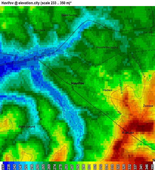
Below is the Elevation map of Havířov, which displays elevation range with different colors. Scale of the first map is from 233 to 350 m (764 to 1148 ft) with average elevation of 278.3 meters (=913 ft) [note 1]
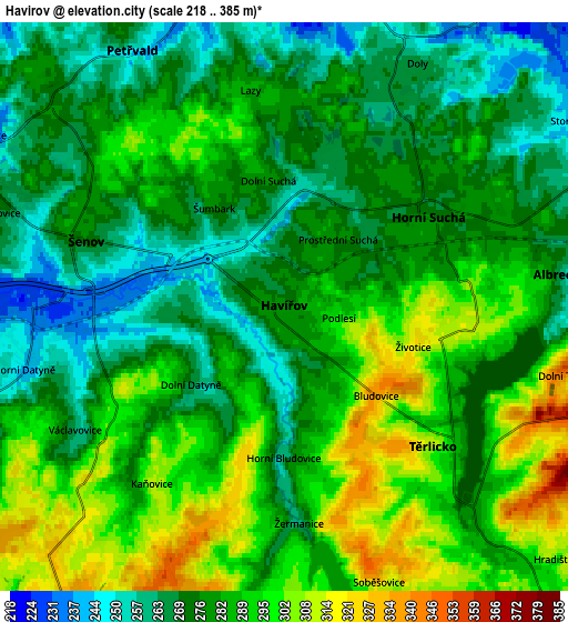
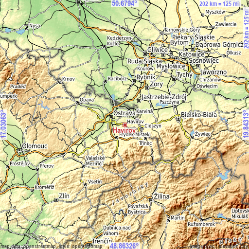
These maps also provides idea of topography and contour of this city, they are displayed at different zoom levels. More info about maps, scale and edge coordinates you can find below images.
| \ | Map #1 | Map #2 | Topo.Map |
| Scale [m] | 233..350 m | 218..385 m | × |
| Scale [ft] | 764..1148 ft | 715..1263 ft | × |
| Average | 278.3 m = 913 ft | 281.6 m = 924 ft | × |
| Width | 6.31 km = 3.9 mi | 12.62 km = 7.8 mi | 201.9 km = 125.5 mi |
| Height | 6.31 km = 3.9 mi | 12.62 km = 7.8 mi | 201.9 km = 125.5 mi |
| ↑Max Latitude | 49.808208° | 49.83656° | 50.6794° |
| Latitude at center | 49.77984° | 49.77984° | 49.77984° |
| ↓Min Latitude | 49.751455° | 49.723053° | 48.86326° |
| ← Min Longitude | 18.392935° | 18.348989° | 17.03063° |
| Longitude center | 18.43688° | 18.43688° | 18.43688° |
| →Max Longitude | 18.480825° | 18.524771° | 19.84313° |
Nearby cities:
Cities around Havířov sort by population:
• Orlová elevation 226 m
7.3 km,  356°
356°
• Petřvald 248 m
6.6 km,  329°
329°
• Vratimov 246 m
9.2 km,  263°
263°
• Šenov 275 m
4.6 km,  288°
288°
• Horní Suchá 277 m
3.8 km,  58°
58°
• Horní Těrlicko 312 m
4.5 km,  133°
133°
• Albrechtice 256 m
6.3 km,  83°
83°
• Stonava 243 m
7.6 km, 56°
• Horní Bludovice 259 m
3.4 km,  180°
180°
• Václavovice 262 m
5.4 km,  239°
239°
• Sedliště 332 m
8.4 km,  215°
215°
• Lučina 303 m
6.6 km,  173°
173°
Multilingual:
 En español:
Havířov elevación 278 m.
 En France:
Havířov élévation 278 m.


Sources and notes:
- [note 1] Map square and city borders are not equal. Map elevation data is calculated only from area inside that square.
- [src 1] Elevation data from geonames database provided with same terms of usage.
- [src 2] The elevation map of Havířov is generated using elevation data from NASA's 3 arcsec (90m) resolution SRTM data.
- [src 3] Base (background) map © OpenStreetMap contributors tiles are generated by Geofabrik and OpenTopoMap.
Copyright & License:
This Havířov Elevation Map is licensed under CC BY-SA. You may reuse any part from this page, if you give a proper credit by linking to this URL:
 More info on terms of use page.