Dobruška elevation
Dobruška (Královéhradecký kraj, Okres Rychnov nad Kněžnou), Czech Republic elevation is 297 meters and Dobruška elevation in feet is 974 ft above sea level [src 1]. Dobruška is a populated place (feature code) with elevation that is 48 meters (157 ft) smaller than average city elevation in Czech Republic.
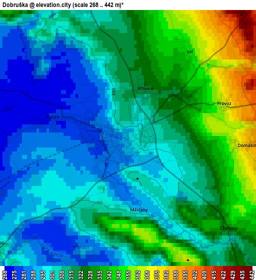
Below is the Elevation map of Dobruška, which displays elevation range with different colors. Scale of the first map is from 268 to 442 m (879 to 1450 ft) with average elevation of 313.9 meters (=1030 ft) [note 1]
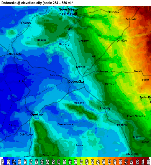
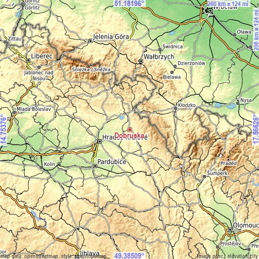
These maps also provides idea of topography and contour of this city, they are displayed at different zoom levels. More info about maps, scale and edge coordinates you can find below images.
| \ | Map #1 | Map #2 | Topo.Map |
| Scale [m] | 268..442 m | 254..556 m | × |
| Scale [ft] | 879..1450 ft | 833..1824 ft | × |
| Average | 313.9 m = 1030 ft | 336.7 m = 1105 ft | × |
| Width | 6.24 km = 3.9 mi | 12.49 km = 7.8 mi | 199.8 km = 124.1 mi |
| Height | 6.24 km = 3.9 mi | 12.49 km = 7.8 mi | 199.8 km = 124.1 mi |
| ↑Max Latitude | 50.320077° | 50.348128° | 51.18196° |
| Latitude at center | 50.29201° | 50.29201° | 50.29201° |
| ↓Min Latitude | 50.263926° | 50.235826° | 49.38509° |
| ← Min Longitude | 16.116065° | 16.072119° | 14.75376° |
| Longitude center | 16.16001° | 16.16001° | 16.16001° |
| →Max Longitude | 16.203955° | 16.247901° | 17.56626° |
Nearby cities:
Cities around Dobruška sort by population:
• Náchod elevation 350 m
13.9 km,  0°
0°
• Rychnov nad Kněžnou 325 m
16.5 km,  150°
150°
• Nové Město nad Metují 334 m
5.9 km,  354°
354°
• Třebechovice pod Orebem 243 m
15.6 km,  229°
229°
• Česká Skalice 291 m
14.1 km,  323°
323°
• Opočno 308 m
4.2 km, 229°
• Dolní Černilov 258 m
14.5 km,  256°
256°
• Solnice 333 m
11.3 km, 150°
• České Meziříčí 258 m
8.2 km,  265°
265°
• Kvasiny 349 m
11.5 km,  140°
140°
• Provodov-Šonov 294 m
11.2 km,  340°
340°
• Skuhrov nad Bělou 383 m
11.7 km,  126°
126°
Multilingual:
 En español:
Dobruška elevación 297 m.
 En France:
Dobruška élévation 297 m.
 Auf Deutsch:
Dobruška höhe über dem Meeresspiegel ist 297 m.

Sources and notes:
- [note 1] Map square and city borders are not equal. Map elevation data is calculated only from area inside that square.
- [src 1] Elevation data from geonames database provided with same terms of usage.
- [src 2] The elevation map of Dobruška is generated using elevation data from NASA's 3 arcsec (90m) resolution SRTM data.
- [src 3] Base (background) map © OpenStreetMap contributors tiles are generated by Geofabrik and OpenTopoMap.
Copyright & License:
This Dobruška Elevation Map is licensed under CC BY-SA. You may reuse any part from this page, if you give a proper credit by linking to this URL:
 More info on terms of use page.