Hlinsko elevation
Hlinsko (Pardubický, Okres Chrudim), Czech Republic elevation is 561 meters and Hlinsko elevation in feet is 1841 ft above sea level [src 1]. Hlinsko is a populated place (feature code) with elevation that is 216 meters (709 ft) bigger than average city elevation in Czech Republic.
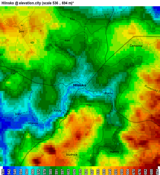
Below is the Elevation map of Hlinsko, which displays elevation range with different colors. Scale of the first map is from 536 to 694 m (1759 to 2277 ft) with average elevation of 608.1 meters (=1995 ft) [note 1]
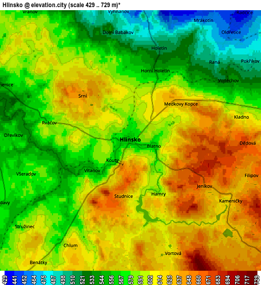
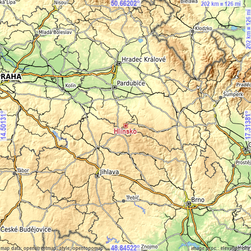
These maps also provides idea of topography and contour of this city, they are displayed at different zoom levels. More info about maps, scale and edge coordinates you can find below images.
| \ | Map #1 | Map #2 | Topo.Map |
| Scale [m] | 536..694 m | 429..729 m | × |
| Scale [ft] | 1759..2277 ft | 1407..2392 ft | × |
| Average | 608.1 m = 1995 ft | 590.1 m = 1936 ft | × |
| Width | 6.31 km = 3.9 mi | 12.63 km = 7.8 mi | 202 km = 125.5 mi |
| Height | 6.31 km = 3.9 mi | 12.63 km = 7.8 mi | 202 km = 125.5 mi |
| ↑Max Latitude | 49.790509° | 49.818871° | 50.66202° |
| Latitude at center | 49.76213° | 49.76213° | 49.76213° |
| ↓Min Latitude | 49.733735° | 49.705323° | 48.84522° |
| ← Min Longitude | 15.863615° | 15.819669° | 14.50131° |
| Longitude center | 15.90756° | 15.90756° | 15.90756° |
| →Max Longitude | 15.951505° | 15.995451° | 17.31381° |
Nearby cities:
Cities around Hlinsko sort by population:
• Chotěboř elevation 525 m
17.7 km,  254°
254°
• Skuteč 412 m
11.1 km,  35°
35°
• Chrast 288 m
15.7 km,  6°
6°
• Luže 306 m
17 km,  30°
30°
• Proseč 519 m
15.8 km,  72°
72°
• Křížová 572 m
9.1 km,  205°
205°
• Svratka 637 m
10.6 km,  122°
122°
• Nasavrky 487 m
11.8 km,  321°
321°
• Krouna 537 m
8.6 km,  82°
82°
• Rosice 261 m
18.1 km, 9°
• Herálec 642 m
10.3 km,  142°
142°
• Miřetice 394 m
8.9 km,  349°
349°
Multilingual:
 En español:
Hlinsko elevación 561 m.
 En France:
Hlinsko élévation 561 m.
 Auf Deutsch:
Hlinsko v Čechách höhe über dem Meeresspiegel ist 561 m.

Sources and notes:
- [note 1] Map square and city borders are not equal. Map elevation data is calculated only from area inside that square.
- [src 1] Elevation data from geonames database provided with same terms of usage.
- [src 2] The elevation map of Hlinsko is generated using elevation data from NASA's 3 arcsec (90m) resolution SRTM data.
- [src 3] Base (background) map © OpenStreetMap contributors tiles are generated by Geofabrik and OpenTopoMap.
Copyright & License:
This Hlinsko Elevation Map is licensed under CC BY-SA. You may reuse any part from this page, if you give a proper credit by linking to this URL:
 More info on terms of use page.