Svratka elevation
Svratka (Vysočina, Okres Žďár nad Sázavou), Czech Republic elevation is 637 meters and Svratka elevation in feet is 2090 ft above sea level [src 1]. Svratka is a populated place (feature code) with elevation that is 292 meters (958 ft) bigger than average city elevation in Czech Republic.
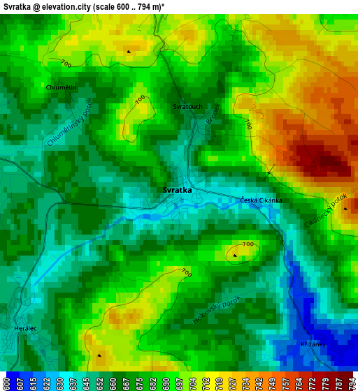
Below is the Elevation map of Svratka, which displays elevation range with different colors. Scale of the first map is from 600 to 794 m (1969 to 2605 ft) with average elevation of 678 meters (=2224 ft) [note 1]
These maps also provides idea of topography and contour of this city, they are displayed at different zoom levels. More info about maps, scale and edge coordinates you can find below images.
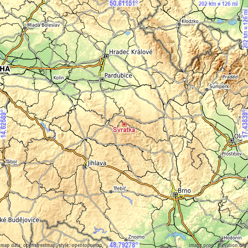
| \ | Map #1 | Topo.Map |
| Scale [m] | 600..794 m | × |
| Scale [ft] | 1969..2605 ft | × |
| Average | 678 m = 2224 ft | × |
| Width | 6.32 km = 3.9 mi | 202.2 km = 125.6 mi |
| Height | 6.32 km = 3.9 mi | 202.2 km = 125.6 mi |
| ↑Max Latitude | 49.739069° | 50.61151° |
| Latitude at center | 49.71066° | 49.71066° |
| ↓Min Latitude | 49.682235° | 48.79278° |
| ← Min Longitude | 15.988195° | 14.62589° |
| Longitude center | 16.03214° | 16.03214° |
| →Max Longitude | 16.076085° | 17.43839° |
Nearby cities:
Cities around Svratka sort by population:
• Žďár nad Sázavou elevation 580 m
17.8 km,  202°
202°
• Žďár nad Sázavou Druhy 578 m
15.5 km,  207°
207°
• Nové Město na Moravě 602 m
16.9 km,  169°
169°
• Hlinsko 561 m
10.6 km,  302°
302°
• Polička 559 m
16.8 km,  88°
88°
• Skuteč 412 m
15 km,  350°
350°
• Proseč 519 m
12.2 km,  29°
29°
• Křížová 572 m
13.2 km,  259°
259°
• Krouna 537 m
6.9 km,  356°
356°
• Herálec 642 m
3.6 km,  228°
228°
• Jimramov 495 m
16.2 km,  120°
120°
• Miřetice 394 m
18 km,  323°
323°
Multilingual:
 En español:
Svratka elevación 637 m.
 En France:
Svratka élévation 637 m.


Sources and notes:
- [note 1] Map square and city borders are not equal. Map elevation data is calculated only from area inside that square.
- [src 1] Elevation data from geonames database provided with same terms of usage.
- [src 2] The elevation map of Svratka is generated using elevation data from NASA's 3 arcsec (90m) resolution SRTM data.
- [src 3] Base (background) map © OpenStreetMap contributors tiles are generated by Geofabrik and OpenTopoMap.
Copyright & License:
This Svratka Elevation Map is licensed under CC BY-SA. You may reuse any part from this page, if you give a proper credit by linking to this URL:
 More info on terms of use page.