Lhenice elevation
Lhenice (Jihočeský kraj, Okres Prachatice), Czech Republic elevation is 557 meters and Lhenice elevation in feet is 1827 ft above sea level [src 1]. Lhenice is a populated place (feature code) with elevation that is 212 meters (696 ft) bigger than average city elevation in Czech Republic.
Below is the Elevation map of Lhenice, which displays elevation range with different colors. Scale of the first map is from 448 to 816 m (1470 to 2677 ft) with average elevation of 569.8 meters (=1869 ft) [note 1]
These maps also provides idea of topography and contour of this city, they are displayed at different zoom levels. More info about maps, scale and edge coordinates you can find below images.
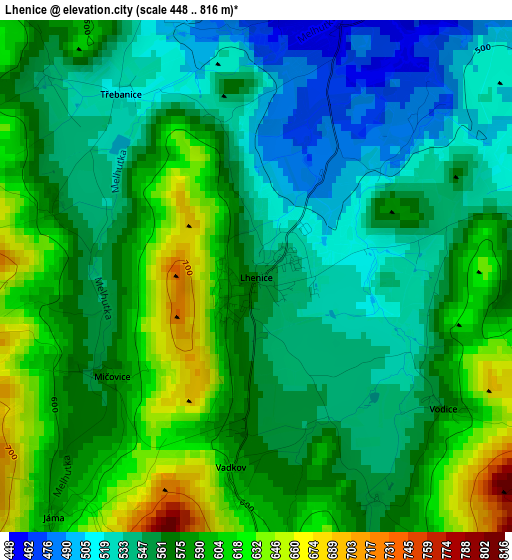
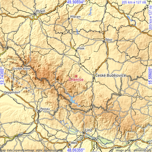
| \ | Map #1 | Topo.Map |
| Scale [m] | 448..816 m | × |
| Scale [ft] | 1470..2677 ft | × |
| Average | 569.8 m = 1869 ft | × |
| Width | 6.41 km = 4 mi | 205.2 km = 127.5 mi |
| Height | 6.41 km = 4 mi | 205.2 km = 127.5 mi |
| ↑Max Latitude | 49.023615° | 49.90894° |
| Latitude at center | 48.99479° | 48.99479° |
| ↓Min Latitude | 48.965948° | 48.06355° |
| ← Min Longitude | 14.105855° | 12.74355° |
| Longitude center | 14.1498° | 14.1498° |
| →Max Longitude | 14.193745° | 15.55605° |
Nearby cities:
Cities around Lhenice sort by population:
• Prachatice elevation 578 m
11.3 km,  280°
280°
• Vodňany 405 m
17.1 km,  6°
6°
• Zliv 391 m
17.7 km,  63°
63°
• Netolice 434 m
7 km,  29°
29°
• Křemže 524 m
15.1 km,  131°
131°
• Vlachovo Březí 552 m
16.9 km,  304°
304°
• Bavorov 441 m
15 km,  339°
339°
• Husinec 514 m
13.6 km, 299°
• Strunkovice nad Blanicí 461 m
12.1 km,  325°
325°
• Chvalšiny 572 m
16.3 km,  164°
164°
• Dubné 411 m
15.5 km,  97°
97°
• Brloh 564 m
8.8 km,  145°
145°
Multilingual:
 En español:
Lhenice elevación 557 m.
 En France:
Lhenice élévation 557 m.


Sources and notes:
- [note 1] Map square and city borders are not equal. Map elevation data is calculated only from area inside that square.
- [src 1] Elevation data from geonames database provided with same terms of usage.
- [src 2] The elevation map of Lhenice is generated using elevation data from NASA's 3 arcsec (90m) resolution SRTM data.
- [src 3] Base (background) map © OpenStreetMap contributors tiles are generated by Geofabrik and OpenTopoMap.
Copyright & License:
This Lhenice Elevation Map is licensed under CC BY-SA. You may reuse any part from this page, if you give a proper credit by linking to this URL:
 More info on terms of use page.