Brloh elevation
Brloh (Jihočeský kraj, Okres Český Krumlov), Czech Republic elevation is 564 meters and Brloh elevation in feet is 1850 ft above sea level [src 1]. Brloh is a populated place (feature code) with elevation that is 219 meters (719 ft) bigger than average city elevation in Czech Republic.
Below is the Elevation map of Brloh, which displays elevation range with different colors. Scale of the first map is from 520 to 960 m (1706 to 3150 ft) with average elevation of 645.8 meters (=2119 ft) [note 1]
These maps also provides idea of topography and contour of this city, they are displayed at different zoom levels. More info about maps, scale and edge coordinates you can find below images.
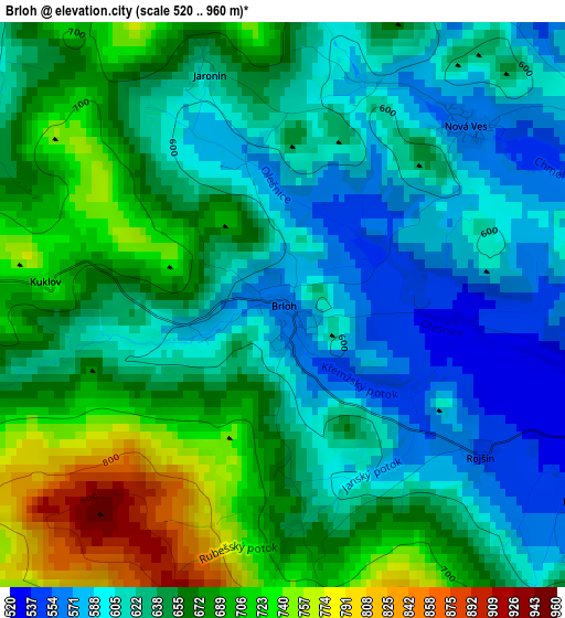
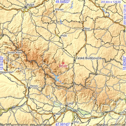
| \ | Map #1 | Topo.Map |
| Scale [m] | 520..960 m | × |
| Scale [ft] | 1706..3150 ft | × |
| Average | 645.8 m = 2119 ft | × |
| Width | 6.42 km = 4 mi | 205.5 km = 127.7 mi |
| Height | 6.42 km = 4 mi | 205.4 km = 127.6 mi |
| ↑Max Latitude | 48.958733° | 49.84522° |
| Latitude at center | 48.92987° | 48.92987° |
| ↓Min Latitude | 48.90099° | 47.99743° |
| ← Min Longitude | 14.174625° | 12.81232° |
| Longitude center | 14.21857° | 14.21857° |
| →Max Longitude | 14.262515° | 15.62482° |
Nearby cities:
Cities around Brloh sort by population:
• Český Krumlov elevation 492 m
15 km,  151°
151°
• Větřní 601 m
18 km,  164°
164°
• Zliv 391 m
18.6 km,  35°
35°
• Netolice 434 m
13.4 km,  353°
353°
• Křemže 524 m
6.9 km,  113°
113°
• Kamenný Újezd 491 m
17 km,  102°
102°
• Lhenice 557 m
8.8 km,  325°
325°
• Včelná 442 m
17.2 km,  92°
92°
• Litvínovice 390 m
17.4 km,  78°
78°
• Kájov 539 m
13.6 km,  167°
167°
• Chvalšiny 572 m
8.5 km,  183°
183°
• Dubné 411 m
11.6 km,  63°
63°
Multilingual:
 En español:
Brloh elevación 564 m.
 En France:
Brloh élévation 564 m.


Sources and notes:
- [note 1] Map square and city borders are not equal. Map elevation data is calculated only from area inside that square.
- [src 1] Elevation data from geonames database provided with same terms of usage.
- [src 2] The elevation map of Brloh is generated using elevation data from NASA's 3 arcsec (90m) resolution SRTM data.
- [src 3] Base (background) map © OpenStreetMap contributors tiles are generated by Geofabrik and OpenTopoMap.
Copyright & License:
This Brloh Elevation Map is licensed under CC BY-SA. You may reuse any part from this page, if you give a proper credit by linking to this URL:
 More info on terms of use page.