Mšeno elevation
Mšeno (Central Bohemia, Okres Mělník), Czech Republic elevation is 359 meters and Mšeno elevation in feet is 1178 ft above sea level [src 1]. Mšeno is a populated place (feature code) with elevation that is 14 meters (46 ft) bigger than average city elevation in Czech Republic.
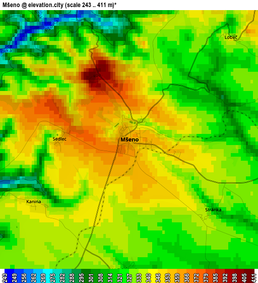
Below is the Elevation map of Mšeno, which displays elevation range with different colors. Scale of the first map is from 243 to 411 m (797 to 1348 ft) with average elevation of 333.3 meters (=1094 ft) [note 1]
These maps also provides idea of topography and contour of this city, they are displayed at different zoom levels. More info about maps, scale and edge coordinates you can find below images.
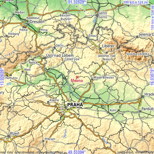
| \ | Map #1 | Topo.Map |
| Scale [m] | 243..411 m | × |
| Scale [ft] | 797..1348 ft | × |
| Average | 333.3 m = 1094 ft | × |
| Width | 6.22 km = 3.9 mi | 199.2 km = 123.8 mi |
| Height | 6.22 km = 3.9 mi | 199.2 km = 123.8 mi |
| ↑Max Latitude | 50.466071° | 51.32529° |
| Latitude at center | 50.43809° | 50.43809° |
| ↓Min Latitude | 50.410092° | 49.53394° |
| ← Min Longitude | 14.588555° | 13.22625° |
| Longitude center | 14.6325° | 14.6325° |
| →Max Longitude | 14.676445° | 16.03875° |
Nearby cities:
Cities around Mšeno sort by population:
• Mladá Boleslav elevation 241 m
19.4 km,  98°
98°
• Mělník 219 m
14.9 km,  229°
229°
• Štětí 160 m
18.4 km,  275°
275°
• Doksy 279 m
14.2 km,  6°
6°
• Bělá pod Bezdězem 297 m
14 km,  59°
59°
• Všetaty 181 m
17.6 km,  189°
189°
• Dubá 270 m
13.1 km,  330°
330°
• Tišice 165 m
19.5 km,  196°
196°
• Dolní Beřkovice 163 m
13.8 km,  248°
248°
• Byšice 200 m
14.3 km, 186°
• Horní Počaply 163 m
17.2 km,  264°
264°
• Cítov 182 m
18.2 km, 246°
Multilingual:
 En español:
Mšeno elevación 359 m.
 En France:
Mšeno élévation 359 m.


Sources and notes:
- [note 1] Map square and city borders are not equal. Map elevation data is calculated only from area inside that square.
- [src 1] Elevation data from geonames database provided with same terms of usage.
- [src 2] The elevation map of Mšeno is generated using elevation data from NASA's 3 arcsec (90m) resolution SRTM data.
- [src 3] Base (background) map © OpenStreetMap contributors tiles are generated by Geofabrik and OpenTopoMap.
Copyright & License:
This Mšeno Elevation Map is licensed under CC BY-SA. You may reuse any part from this page, if you give a proper credit by linking to this URL:
 More info on terms of use page.