Nedakonice elevation
Nedakonice (Zlín, Okres Uherské Hradiště), Czech Republic elevation is 176 meters and Nedakonice elevation in feet is 577 ft above sea level [src 1]. Nedakonice is a populated place (feature code) with elevation that is 169 meters (554 ft) smaller than average city elevation in Czech Republic.
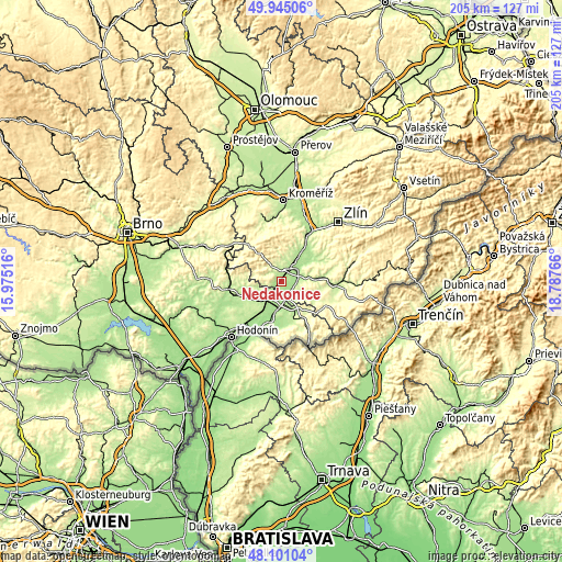
Below is the Elevation map of Nedakonice, which displays elevation range with different colors. Scale of the first map is from 166 to 336 m (545 to 1102 ft) with average elevation of 187.8 meters (=616 ft) [note 1]
These maps also provides idea of topography and contour of this city, they are displayed at different zoom levels. More info about maps, scale and edge coordinates you can find below images.

| \ | Map #1 | Topo.Map |
| Scale [m] | 166..336 m | × |
| Scale [ft] | 545..1102 ft | × |
| Average | 187.8 m = 616 ft | × |
| Width | 6.41 km = 4 mi | 205 km = 127.4 mi |
| Height | 6.41 km = 4 mi | 205 km = 127.4 mi |
| ↑Max Latitude | 49.060394° | 49.94506° |
| Latitude at center | 49.03159° | 49.03159° |
| ↓Min Latitude | 49.002769° | 48.10104° |
| ← Min Longitude | 17.337465° | 15.97516° |
| Longitude center | 17.38141° | 17.38141° |
| →Max Longitude | 17.425355° | 18.78766° |
Nearby cities:
Cities around Nedakonice sort by population:
• Uherské Hradiště elevation 182 m
7.1 km,  53°
53°
• Staré Město 192 m
6.1 km,  38°
38°
• Kunovice 181 m
6.6 km,  77°
77°
• Uherský Ostroh 178 m
5.2 km,  173°
173°
• Ostrožská Nová Ves 181 m
5 km,  127°
127°
• Buchlovice 250 m
6.8 km,  332°
332°
• Boršice 209 m
4.1 km, 327°
• Moravský Písek 178 m
5.8 km,  217°
217°
• Polešovice 227 m
3 km,  274°
274°
• Zlechov 204 m
4.7 km,  358°
358°
• Tupesy 214 m
5.9 km,  351°
351°
• Domanín 229 m
7.8 km,  244°
244°
Multilingual:
 En español:
Nedakonice elevación 176 m.
 En France:
Nedakonice élévation 176 m.
 Auf Deutsch:
Nedakonice höhe über dem Meeresspiegel ist 176 m.

Sources and notes:
- [note 1] Map square and city borders are not equal. Map elevation data is calculated only from area inside that square.
- [src 1] Elevation data from geonames database provided with same terms of usage.
- [src 2] The elevation map of Nedakonice is generated using elevation data from NASA's 3 arcsec (90m) resolution SRTM data.
- [src 3] Base (background) map © OpenStreetMap contributors tiles are generated by Geofabrik and OpenTopoMap.
Copyright & License:
This Nedakonice Elevation Map is licensed under CC BY-SA. You may reuse any part from this page, if you give a proper credit by linking to this URL:
 More info on terms of use page.