Uherské Hradiště elevation
Uherské Hradiště (Zlín, Okres Uherské Hradiště), Czech Republic elevation is 182 meters and Uherské Hradiště elevation in feet is 597 ft above sea level [src 1]. Uherské Hradiště is a populated place (feature code) with elevation that is 163 meters (535 ft) smaller than average city elevation in Czech Republic.
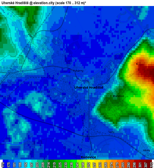
Below is the Elevation map of Uherské Hradiště, which displays elevation range with different colors. Scale of the first map is from 170 to 312 m (558 to 1024 ft) with average elevation of 189.5 meters (=622 ft) [note 1]
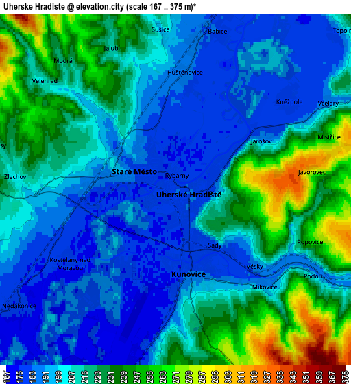
These maps also provides idea of topography and contour of this city, they are displayed at different zoom levels. More info about maps, scale and edge coordinates you can find below images.
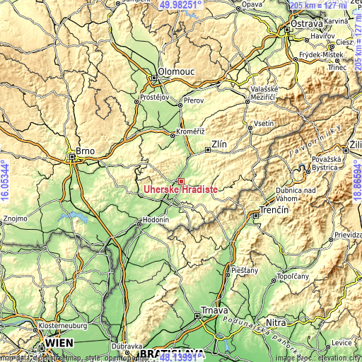
| \ | Map #1 | Map #2 | Topo.Map |
| Scale [m] | 170..312 m | 167..375 m | × |
| Scale [ft] | 558..1024 ft | 548..1230 ft | × |
| Average | 189.5 m = 622 ft | 210.9 m = 692 ft | × |
| Width | 6.4 km = 4 mi | 12.8 km = 8 mi | 204.9 km = 127.3 mi |
| Height | 6.4 km = 4 mi | 12.8 km = 8 mi | 204.9 km = 127.3 mi |
| ↑Max Latitude | 49.098532° | 49.127297° | 49.98251° |
| Latitude at center | 49.06975° | 49.06975° | 49.06975° |
| ↓Min Latitude | 49.040951° | 49.012136° | 48.13991° |
| ← Min Longitude | 17.415745° | 17.371799° | 16.05344° |
| Longitude center | 17.45969° | 17.45969° | 17.45969° |
| →Max Longitude | 17.503635° | 17.547581° | 18.86594° |
Nearby cities:
Cities around Uherské Hradiště sort by population:
• Staré Město elevation 192 m
2 km,  287°
287°
• Kunovice 181 m
2.9 km,  164°
164°
• Babice 182 m
6 km,  14°
14°
• Jalubí 210 m
5.7 km,  335°
335°
• Zlechov 204 m
5.9 km,  274°
274°
• Nedakonice 176 m
7.1 km,  233°
233°
• Velehrad 212 m
6.2 km,  309°
309°
• Mistřice 250 m
5.9 km,  71°
71°
• Traplice 211 m
7 km,  345°
345°
• Tupesy 214 m
6.7 km,  283°
283°
• Popovice 262 m
5.3 km,  111°
111°
• Kněžpole 180 m
5.2 km,  52°
52°
Multilingual:
 En español:
Uherské Hradiště elevación 182 m.
 En France:
Uherské Hradiště élévation 182 m.
 Auf Deutsch:
Ungarisch Hradisch, Uherské Hradiště, Ungarisch-Hradisch höhe über dem Meeresspiegel ist 182 m.

Sources and notes:
- [note 1] Map square and city borders are not equal. Map elevation data is calculated only from area inside that square.
- [src 1] Elevation data from geonames database provided with same terms of usage.
- [src 2] The elevation map of Uherské Hradiště is generated using elevation data from NASA's 3 arcsec (90m) resolution SRTM data.
- [src 3] Base (background) map © OpenStreetMap contributors tiles are generated by Geofabrik and OpenTopoMap.
Copyright & License:
This Uherské Hradiště Elevation Map is licensed under CC BY-SA. You may reuse any part from this page, if you give a proper credit by linking to this URL:
 More info on terms of use page.